Sankt Leon-Rot geodata
Sankt Leon-Rot (Baden-Württemberg) is a populated place; located in Germany in Europe/Berlin (GMT+2) time zone. With population of 12,192 people, there are 1341 cities with bigger population in this country. Compared to other cities in Germany, 79.3% of cities are located further ↑North; 69.9% of cities are located further →East and 66.7% of cities have higher elevation than Sankt Leon-Rot. Note1
Administrative division(s):
- Level 1: Baden-Württemberg
- Level 2: Karlsruhe Region
- Level 3: Rhein-Neckar-Kreis
- Level 4: St. Leon-Rot


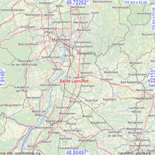
Sankt Leon-Rot GPS coordinates[2]
49° 15' 57.348" North, 8° 37' 4.908" East
| Map corner | latitude | longitude |
|---|---|---|
| Upper-left | 49.72262°, | 7.9149° |
| Center: | 49.26593°, | 8.61803° |
| Lower-right: | 48.80497°, | 9.32115° |
| Map W x H: | 102×102 km | = 63.4×63.4mi |
| max Lat: | 55.01917° ⇑79.3% North |
| Sankt Leon-Rot: | 49.26593° |
| min Lat: | ⇓20.7% South 47.40724° |
| min Long | Sankt Leon-Rot | max Long |
| 5.92978° | 8.61803° | 14.98853° |
| W 30.1%⇐ | ⇒69.9% E |
Elevation
Elevation of Sankt Leon-Rot is 110 m = 361 ft, and this is 139.1 m = 456 ft below average elevation for this country.
| Max E: |
1256 m = 4121 ft | 66.7% |
| Avg. | 249.1 m = 817 ft | |
| Sankt Leon-Rot | 110 m = 361 ft | |
Min E: |
-5 m = -16 ft | 33.3% |
See also: Germany elevation on elevation.city.
Geographical zone
Sankt Leon-Rot is located in North temperate zone (between Tropic of Cancer and the Arctic Circle). Distance of this North polar circle is 1923.3 km =1195.1 mi to North.| Distance of | km | miles | from Sankt Leon-Rot |
|---|---|---|---|
| North Pole | 4529.2 | 2814.3 | to North |
| Arctic Circle | 1923.3 | 1195.1 | to North |
| Tropic Cancer | 2871.9 | 1784.5 | to South |
| Equator | 5477.9 | 3403.8 | to South |


Nearby cities:
15 places around Sankt Leon-Rot: (largest is in red/bold)
• Altlußheim
9.5 km =5.9 mi,  294°
294°
• Dielheim
8.9 km =5.5 mi,  76°
76°
• Hockenheim
8 km =5 mi,  323°
323°
• Kronau
4.9 km =3 mi,  168°
168°
• Malsch
5.1 km =3.2 mi,  113°
113°
• Mühlhausen
8.1 km =5 mi,  103°
103°
• Neulußheim
8.1 km =5 mi,  296°
296°
• Nußloch
8.6 km =5.3 mi,  41°
41°
• Rauenberg
6.2 km =3.9 mi,  86°
86°
• Reilingen
5.3 km =3.3 mi,  312°
312°
• Sandhausen
9.1 km =5.7 mi,  19°
19°
• Waghäusel
7.9 km =4.9 mi,  256°
256°
• Walldorf
4.8 km =3 mi, 21°
• Wiesloch
6.7 km =4.2 mi,  60°
60°
• Östringen
8.6 km =5.3 mi,  127°
127°
Sources, notices
• [Note1] Compared only with cities in Germany existing in our database
• [Src1] Map data: © OpenStreetMap contributors (CC-BY-SA)
• [Src2] Other city data from geonames.org with taken over terms of usage.
• [Src3] Geographical zone / Annual Mean Temperature by Robert A. Rohde @ Wikipedia
