Waldheim geodata
Waldheim (Saxony) is a populated place; located in Germany in Europe/Berlin (GMT+2) time zone. With population of 9,001 people, there are 1788 cities with bigger population in this country. Compared to other cities in Germany, 59.4% of cities are located further ↓South; 92.4% of cities are located further ←West and 54.7% of cities have higher elevation than Waldheim. Note1


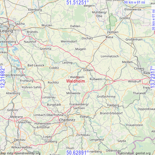
Waldheim GPS coordinates[2]
51° 4' 22.152" North, 13° 1' 12.144" East
| Map corner | latitude | longitude |
|---|---|---|
| Upper-left | 51.51251°, | 12.31692° |
| Center: | 51.07282°, | 13.02004° |
| Lower-right: | 50.62891°, | 13.72317° |
| Map W x H: | 98.2×98.2 km | = 61×61mi |
| max Lat: | 55.01917° ⇑40.6% North |
| Waldheim: | 51.07282° |
| min Lat: | ⇓59.4% South 47.40724° |
| min Long | Waldheim | max Long |
| 5.92978° | 13.02004° | 14.98853° |
| W 92.4%⇐ | ⇒7.6% E |
Elevation
Elevation of Waldheim is 191 m = 627 ft, and this is 58.1 m = 191 ft below average elevation for this country.
| Max E: |
1256 m = 4121 ft | 54.7% |
| Avg. | 249.1 m = 817 ft | |
| Waldheim | 191 m = 627 ft | |
Min E: |
-5 m = -16 ft | 45.3% |
See also: Germany elevation on elevation.city.
Geographical zone
Waldheim is located in North temperate zone (between Tropic of Cancer and the Arctic Circle). Distance of this North polar circle is 1722.4 km =1070.2 mi to North.| Distance of | km | miles | from Waldheim |
|---|---|---|---|
| North Pole | 4328.3 | 2689.5 | to North |
| Arctic Circle | 1722.4 | 1070.2 | to North |
| Tropic Cancer | 3072.8 | 1909.3 | to South |
| Equator | 5678.8 | 3528.6 | to South |


Nearby cities:
15 places around Waldheim: (largest is in red/bold)
• Altmittweida
12.8 km =8 mi,  202°
202°
• Döbeln
8.3 km =5.2 mi,  48°
48°
• Ebersbach
7.1 km =4.4 mi,  65°
65°
• Erlau
8.8 km =5.5 mi,  216°
216°
• Geringswalde
7.9 km =4.9 mi,  273°
273°
• Gersdorf
7.2 km =4.5 mi,  307°
307°
• Großweitzschen
9.7 km =6 mi,  10°
10°
• Hartha
4.3 km =2.7 mi, 311°
• Kriebstein
2.5 km =1.6 mi,  185°
185°
• Leisnig
11.4 km =7.1 mi,  325°
325°
• Mittweida
10.1 km =6.3 mi, 197°
• Niederstriegis
9.1 km =5.7 mi,  83°
83°
• Rossau
8.7 km =5.4 mi,  158°
158°
• Roßwein
11.4 km =7.1 mi,  93°
93°
• Zettlitz
13.1 km =8.1 mi, 266°
Sources, notices
• [Note1] Compared only with cities in Germany existing in our database
• [Src1] Map data: © OpenStreetMap contributors (CC-BY-SA)
• [Src2] Other city data from geonames.org with taken over terms of usage.
• [Src3] Geographical zone / Annual Mean Temperature by Robert A. Rohde @ Wikipedia
