Mittweida geodata
Mittweida (Saxony) is a populated place; located in Germany in Europe/Berlin (GMT+2) time zone. With population of 16,619 people, there are 950 cities with bigger population in this country. Compared to other cities in Germany, 57.9% of cities are located further ↓South; 92.1% of cities are located further ←West and 57.6% of cities have lower elevation than Mittweida. Note1


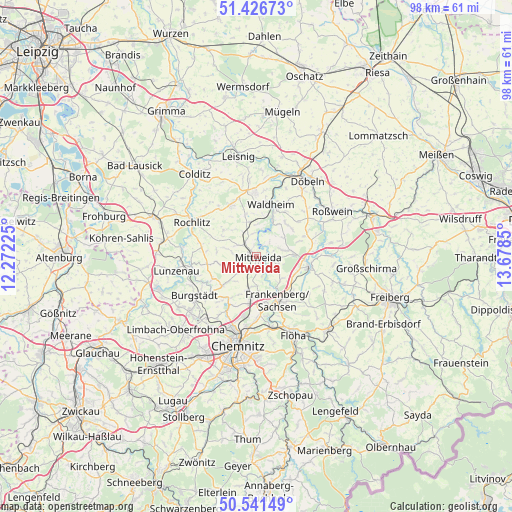
Mittweida GPS coordinates[2]
50° 59' 10.392" North, 12° 58' 31.332" East
| Map corner | latitude | longitude |
|---|---|---|
| Upper-left | 51.42673°, | 12.27225° |
| Center: | 50.98622°, | 12.97537° |
| Lower-right: | 50.54149°, | 13.6785° |
| Map W x H: | 98.4×98.4 km | = 61.1×61.1mi |
| max Lat: | 55.01917° ⇑42.1% North |
| Mittweida: | 50.98622° |
| min Lat: | ⇓57.9% South 47.40724° |
| min Long | Mittweida | max Long |
| 5.92978° | 12.97537° | 14.98853° |
| W 92.1%⇐ | ⇒7.9% E |
Elevation
Elevation of Mittweida is 276 m = 906 ft, and this is 26.9 m = 88 ft above average elevation for this country.
| Max E: |
1256 m = 4121 ft | 42.4% |
| Mittweida | 276 m 906 ft | |
| Avg. | 249.1 m = 817 ft | |
Min E: |
-5 m = -16 ft | 57.6% |
See also: Germany elevation on elevation.city.
Geographical zone
Mittweida is located in North temperate zone (between Tropic of Cancer and the Arctic Circle). Distance of this North polar circle is 1732 km =1076.2 mi to North.| Distance of | km | miles | from Mittweida |
|---|---|---|---|
| North Pole | 4337.9 | 2695.4 | to North |
| Arctic Circle | 1732 | 1076.2 | to North |
| Tropic Cancer | 3063.2 | 1903.4 | to South |
| Equator | 5669.1 | 3522.6 | to South |


Nearby cities:
15 places around Mittweida: (largest is in red/bold)
• Altmittweida
2.8 km =1.7 mi,  219°
219°
• Claußnitz
8.7 km =5.4 mi,  227°
227°
• Erlau
3.3 km =2.1 mi,  320°
320°
• Frankenberg
9.3 km =5.8 mi,  150°
150°
• Geringswalde
11.1 km =6.9 mi,  334°
334°
• Hainichen
10.5 km =6.5 mi,  99°
99°
• Hartha
12.5 km =7.8 mi,  359°
359°
• Kriebstein
7.7 km =4.8 mi,  22°
22°
• Niederwiesa
13.6 km =8.5 mi,  167°
167°
• Rossau
6.6 km =4.1 mi,  76°
76°
• Seelitz
12.3 km =7.6 mi,  295°
295°
• Taura
11.7 km =7.3 mi, 228°
• Waldheim
10.1 km =6.3 mi, 17°
• Wittgensdorf
13.6 km =8.5 mi,  212°
212°
• Zettlitz
13.4 km =8.3 mi,  312°
312°
Sources, notices
• [Note1] Compared only with cities in Germany existing in our database
• [Src1] Map data: © OpenStreetMap contributors (CC-BY-SA)
• [Src2] Other city data from geonames.org with taken over terms of usage.
• [Src3] Geographical zone / Annual Mean Temperature by Robert A. Rohde @ Wikipedia
