Vockerode geodata
Vockerode (Saxony-Anhalt) is a populated place; located in Germany in Europe/Berlin (GMT+2) time zone. With population of 1,741 people, there are 5438 cities with bigger population in this country. Compared to other cities in Germany, 70.5% of cities are located further ↓South; 86.4% of cities are located further ←West and 75.5% of cities have higher elevation than Vockerode. Note1
Administrative division(s):
- Level 1: Saxony-Anhalt
- Level 3: Landkreis Wittenberg
- Level 4: Oranienbaum-Wörlitz


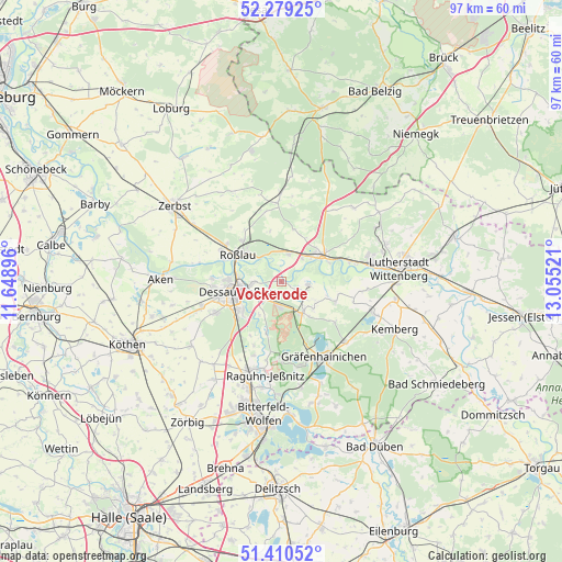
Vockerode GPS coordinates[2]
51° 50' 49.128" North, 12° 21' 7.488" East
| Map corner | latitude | longitude |
|---|---|---|
| Upper-left | 52.27925°, | 11.64896° |
| Center: | 51.84698°, | 12.35208° |
| Lower-right: | 51.41052°, | 13.05521° |
| Map W x H: | 96.6×96.6 km | = 60×60mi |
| max Lat: | 55.01917° ⇑29.5% North |
| Vockerode: | 51.84698° |
| min Lat: | ⇓70.5% South 47.40724° |
| min Long | Vockerode | max Long |
| 5.92978° | 12.35208° | 14.98853° |
| W 86.4%⇐ | ⇒13.6% E |
Elevation
Elevation of Vockerode is 61 m = 200 ft, and this is 188.1 m = 617 ft below average elevation for this country.
| Max E: |
1256 m = 4121 ft | 75.5% |
| Avg. | 249.1 m = 817 ft | |
| Vockerode | 61 m = 200 ft | |
Min E: |
-5 m = -16 ft | 24.5% |
See also: Germany elevation on elevation.city.
Geographical zone
Vockerode is located in North temperate zone (between Tropic of Cancer and the Arctic Circle). Distance of this North polar circle is 1636.3 km =1016.7 mi to North.| Distance of | km | miles | from Vockerode |
|---|---|---|---|
| North Pole | 4242.2 | 2636 | to North |
| Arctic Circle | 1636.3 | 1016.7 | to North |
| Tropic Cancer | 3158.9 | 1962.8 | to South |
| Equator | 5764.8 | 3582.1 | to South |


Nearby cities:
15 places around Vockerode: (largest is in red/bold)
• Coswig
8 km =5 mi,  57°
57°
• Dessau
7.4 km =4.6 mi,  262°
262°
• Griebo
11.4 km =7.1 mi,  70°
70°
• Horstdorf
6.1 km =3.8 mi,  119°
119°
• Jüdenberg
11.6 km =7.2 mi,  158°
158°
• Kakau
7.3 km =4.5 mi,  130°
130°
• Klieken
4.7 km =2.9 mi,  15°
15°
• Möhlau
12.9 km =8 mi,  179°
179°
• Oranienbaum
6.5 km =4 mi,  145°
145°
• Rodleben
11.7 km =7.3 mi,  297°
297°
• Roßlau
8.8 km =5.5 mi, 300°
• Schierau
11.9 km =7.4 mi,  203°
203°
• Schleesen
11.6 km =7.2 mi, 126°
• Thießen
12.6 km =7.8 mi,  343°
343°
• Wörlitz
4.8 km =3 mi,  97°
97°
Sources, notices
• [Note1] Compared only with cities in Germany existing in our database
• [Src1] Map data: © OpenStreetMap contributors (CC-BY-SA)
• [Src2] Other city data from geonames.org with taken over terms of usage.
• [Src3] Geographical zone / Annual Mean Temperature by Robert A. Rohde @ Wikipedia
