Dessau geodata
Dessau (Saxony-Anhalt) is a populated place; located in Germany in Europe/Berlin (GMT+2) time zone. With population of 77,315 people, there are 131 cities with bigger population in this country. Compared to other cities in Germany, 70.4% of cities are located further ↓South; 85.2% of cities are located further ←West and 75% of cities have higher elevation than Dessau. Note1


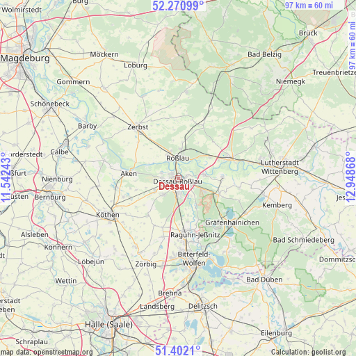
Dessau GPS coordinates[2]
51° 50' 19.104" North, 12° 14' 43.98" East
| Map corner | latitude | longitude |
|---|---|---|
| Upper-left | 52.27099°, | 11.54243° |
| Center: | 51.83864°, | 12.24555° |
| Lower-right: | 51.4021°, | 12.94868° |
| Map W x H: | 96.6×96.6 km | = 60×60mi |
| max Lat: | 55.01917° ⇑29.6% North |
| Dessau: | 51.83864° |
| min Lat: | ⇓70.4% South 47.40724° |
| min Long | Dessau | max Long |
| 5.92978° | 12.24555° | 14.98853° |
| W 85.2%⇐ | ⇒14.8% E |
Elevation
Elevation of Dessau is 63 m = 207 ft, and this is 186.1 m = 611 ft below average elevation for this country.
| Max E: |
1256 m = 4121 ft | 75% |
| Avg. | 249.1 m = 817 ft | |
| Dessau | 63 m = 207 ft | |
Min E: |
-5 m = -16 ft | 25% |
See also: Dessau elevation on elevation.city.
Geographical zone
Dessau is located in North temperate zone (between Tropic of Cancer and the Arctic Circle). Distance of this North polar circle is 1637.3 km =1017.4 mi to North.| Distance of | km | miles | from Dessau |
|---|---|---|---|
| North Pole | 4243.1 | 2636.5 | to North |
| Arctic Circle | 1637.3 | 1017.4 | to North |
| Tropic Cancer | 3158 | 1962.3 | to South |
| Equator | 5763.9 | 3581.5 | to South |


Nearby cities:
15 places around Dessau: (largest is in red/bold)
• Aken
13.9 km =8.6 mi,  276°
276°
• Horstdorf
12.8 km =8 mi,  99°
99°
• Jütrichau
13.5 km =8.4 mi,  324°
324°
• Kakau
13.4 km =8.3 mi,  106°
106°
• Klieken
10.2 km =6.3 mi,  57°
57°
• Möhlau
14 km =8.7 mi,  148°
148°
• Oranienbaum
11.9 km =7.4 mi, 112°
• Quellendorf
12.8 km =8 mi,  219°
219°
• Rodleben
7.1 km =4.4 mi,  334°
334°
• Roßlau
5.4 km =3.4 mi,  357°
357°
• Schierau
10.4 km =6.5 mi,  165°
165°
• Steutz
12.3 km =7.6 mi,  290°
290°
• Thießen
13.5 km =8.4 mi,  15°
15°
• Vockerode
7.4 km =4.6 mi,  82°
82°
• Wörlitz
12.1 km =7.5 mi,  88°
88°
Sources, notices
• [Note1] Compared only with cities in Germany existing in our database
• [Src1] Map data: © OpenStreetMap contributors (CC-BY-SA)
• [Src2] Other city data from geonames.org with taken over terms of usage.
• [Src3] Geographical zone / Annual Mean Temperature by Robert A. Rohde @ Wikipedia
