Glonn geodata
Glonn (Bavaria) is a populated place; located in Germany in Europe/Berlin (GMT+2) time zone. With population of 4,317 people, there are 3125 cities with bigger population in this country. Compared to other cities in Germany, 95.7% of cities are located further ↑North; 79.8% of cities are located further ←West and 91.5% of cities have lower elevation than Glonn. Note1
Administrative division(s):
- Level 1: Bavaria
- Level 2: Upper Bavaria
- Level 3: Landkreis Ebersberg
- Level 4: Glonn, Markt


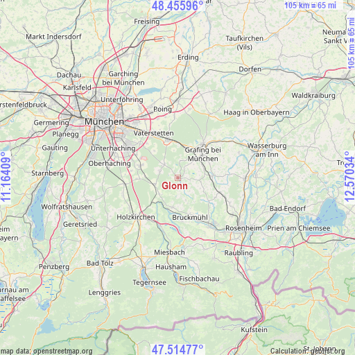
Glonn GPS coordinates[2]
47° 59' 15.036" North, 11° 52' 1.956" East
| Map corner | latitude | longitude |
|---|---|---|
| Upper-left | 48.45596°, | 11.16409° |
| Center: | 47.98751°, | 11.86721° |
| Lower-right: | 47.51477°, | 12.57034° |
| Map W x H: | 104.7×104.6 km | = 65.1×65mi |
| max Lat: | 55.01917° ⇑95.7% North |
| Glonn: | 47.98751° |
| min Lat: | ⇓4.3% South 47.40724° |
| min Long | Glonn | max Long |
| 5.92978° | 11.86721° | 14.98853° |
| W 79.8%⇐ | ⇒20.2% E |
Elevation
Elevation of Glonn is 535 m = 1755 ft, and this is 285.9 m = 938 ft above average elevation for this country.
| Max E: |
1256 m = 4121 ft | 8.5% |
| Glonn | 535 m 1755 ft | |
| Avg. | 249.1 m = 817 ft | |
Min E: |
-5 m = -16 ft | 91.5% |
See also: Germany elevation on elevation.city.
Geographical zone
Glonn is located in North temperate zone (between Tropic of Cancer and the Arctic Circle). Distance of this North polar circle is 2065.5 km =1283.4 mi to North.| Distance of | km | miles | from Glonn |
|---|---|---|---|
| North Pole | 4671.4 | 2902.7 | to North |
| Arctic Circle | 2065.5 | 1283.4 | to North |
| Tropic Cancer | 2729.8 | 1696.2 | to South |
| Equator | 5335.7 | 3315.4 | to South |


Nearby cities:
15 places around Glonn: (largest is in red/bold)
• Aying
7 km =4.3 mi,  253°
253°
• Aßling
10.4 km =6.5 mi,  86°
86°
• Bruck
4.8 km =3 mi,  38°
38°
• Bruckmühl
12.5 km =7.8 mi,  164°
164°
• Egmating
5.7 km =3.5 mi,  288°
288°
• Feldkirchen-Westerham
9.1 km =5.7 mi,  191°
191°
• Grafing bei München
9.9 km =6.2 mi,  49°
49°
• Hohenthann
6.8 km =4.2 mi,  99°
99°
• Höhenkirchen-Siegertsbrunn
11.6 km =7.2 mi, 287°
• Kirchseeon
9.5 km =5.9 mi,  9°
9°
• Moosach
5 km =3.1 mi, 6°
• Oberpframmern
5.5 km =3.4 mi,  313°
313°
• Tuntenhausen
12.5 km =7.8 mi,  117°
117°
• Valley
12.4 km =7.7 mi,  211°
211°
• Zorneding
11.2 km =7 mi,  343°
343°
Sources, notices
• [Note1] Compared only with cities in Germany existing in our database
• [Src1] Map data: © OpenStreetMap contributors (CC-BY-SA)
• [Src2] Other city data from geonames.org with taken over terms of usage.
• [Src3] Geographical zone / Annual Mean Temperature by Robert A. Rohde @ Wikipedia
