Uslar geodata
Uslar (Lower Saxony) is a populated place; located in Germany in Europe/Berlin (GMT+2) time zone. With population of 15,951 people, there are 1007 cities with bigger population in this country. Compared to other cities in Germany, 68.4% of cities are located further ↓South; 55.5% of cities are located further →East and 58.1% of cities have higher elevation than Uslar. Note1


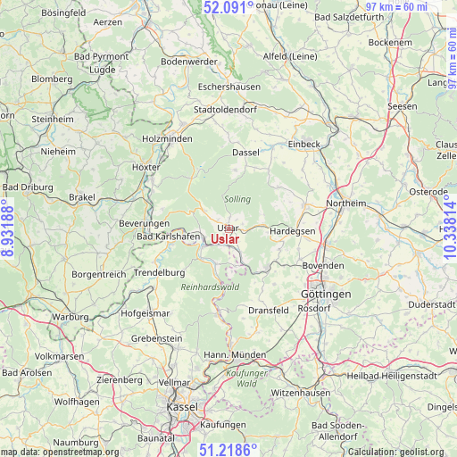
Uslar GPS coordinates[2]
51° 39' 24.84" North, 9° 38' 6.036" East
| Map corner | latitude | longitude |
|---|---|---|
| Upper-left | 52.091°, | 8.93188° |
| Center: | 51.6569°, | 9.63501° |
| Lower-right: | 51.2186°, | 10.33814° |
| Map W x H: | 97×97 km | = 60.3×60.3mi |
| max Lat: | 55.01917° ⇑31.6% North |
| Uslar: | 51.6569° |
| min Lat: | ⇓68.4% South 47.40724° |
| min Long | Uslar | max Long |
| 5.92978° | 9.63501° | 14.98853° |
| W 44.5%⇐ | ⇒55.5% E |
Elevation
Elevation of Uslar is 167 m = 548 ft, and this is 82.1 m = 269 ft below average elevation for this country.
| Max E: |
1256 m = 4121 ft | 58.1% |
| Avg. | 249.1 m = 817 ft | |
| Uslar | 167 m = 548 ft | |
Min E: |
-5 m = -16 ft | 41.9% |
See also: Germany elevation on elevation.city.
Geographical zone
Uslar is located in North temperate zone (between Tropic of Cancer and the Arctic Circle). Distance of this North polar circle is 1657.5 km =1029.9 mi to North.| Distance of | km | miles | from Uslar |
|---|---|---|---|
| North Pole | 4263.4 | 2649.2 | to North |
| Arctic Circle | 1657.5 | 1029.9 | to North |
| Tropic Cancer | 3137.8 | 1949.7 | to South |
| Equator | 5743.7 | 3569 | to South |


Nearby cities:
15 places around Uslar: (largest is in red/bold)
• Adelebsen
11.7 km =7.3 mi,  134°
134°
• Bad Karlshafen
12.5 km =7.8 mi,  262°
262°
• Beverungen
18 km =11.2 mi,  273°
273°
• Bodenfelde
5.8 km =3.6 mi,  251°
251°
• Boffzen
20.2 km =12.6 mi,  300°
300°
• Bühren
19.6 km =12.2 mi,  170°
170°
• Dassel
16.5 km =10.3 mi,  13°
13°
• Derental
14.6 km =9.1 mi,  286°
286°
• Dransfeld
19.6 km =12.2 mi,  153°
153°
• Fürstenberg
18.3 km =11.4 mi, 297°
• Hardegsen
13.5 km =8.4 mi,  92°
92°
• Heinade
19.6 km =12.2 mi,  359°
359°
• Moringen
16.9 km =10.5 mi,  73°
73°
• Nörten-Hardenberg
21 km =13 mi,  98°
98°
• Trendelburg
17.4 km =10.8 mi,  238°
238°
Sources, notices
• [Note1] Compared only with cities in Germany existing in our database
• [Src1] Map data: © OpenStreetMap contributors (CC-BY-SA)
• [Src2] Other city data from geonames.org with taken over terms of usage.
• [Src3] Geographical zone / Annual Mean Temperature by Robert A. Rohde @ Wikipedia
