Bötzingen geodata
Bötzingen (Baden-Württemberg) is a seat of a fourth-order administrative division; located in Germany in Europe/Berlin (GMT+2) time zone. With population of 5,239 people, there are 2720 cities with bigger population in this country. Compared to other cities in Germany, 94.4% of cities are located further ↑North; 82.6% of cities are located further →East and 54.6% of cities have higher elevation than Bötzingen. Note1
Administrative division(s):
- Level 1: Baden-Württemberg
- Level 2: Freiburg Region
- Level 3: Landkreis Breisgau-Hochschwarzwald
- Level 4: Bötzingen


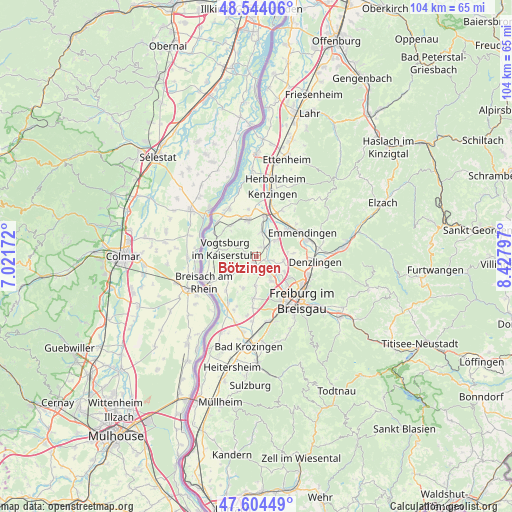
Bötzingen GPS coordinates[2]
48° 4' 35.112" North, 7° 43' 29.46" East
| Map corner | latitude | longitude |
|---|---|---|
| Upper-left | 48.54406°, | 7.02172° |
| Center: | 48.07642°, | 7.72485° |
| Lower-right: | 47.60449°, | 8.42797° |
| Map W x H: | 104.5×104.5 km | = 64.9×64.9mi |
| max Lat: | 55.01917° ⇑94.4% North |
| Bötzingen: | 48.07642° |
| min Lat: | ⇓5.6% South 47.40724° |
| min Long | Bötzingen | max Long |
| 5.92978° | 7.72485° | 14.98853° |
| W 17.4%⇐ | ⇒82.6% E |
Elevation
Elevation of Bötzingen is 192 m = 630 ft, and this is 57.1 m = 187 ft below average elevation for this country.
| Max E: |
1256 m = 4121 ft | 54.6% |
| Avg. | 249.1 m = 817 ft | |
| Bötzingen | 192 m = 630 ft | |
Min E: |
-5 m = -16 ft | 45.4% |
See also: Germany elevation on elevation.city.
Geographical zone
Bötzingen is located in North temperate zone (between Tropic of Cancer and the Arctic Circle). Distance of this North polar circle is 2055.6 km =1277.3 mi to North.| Distance of | km | miles | from Bötzingen |
|---|---|---|---|
| North Pole | 4661.5 | 2896.5 | to North |
| Arctic Circle | 2055.6 | 1277.3 | to North |
| Tropic Cancer | 2739.7 | 1702.4 | to South |
| Equator | 5345.6 | 3321.6 | to South |


Nearby cities:
15 places around Bötzingen: (largest is in red/bold)
• Bahlingen
5 km =3.1 mi,  12°
12°
• Bischoffingen
7.9 km =4.9 mi,  293°
293°
• Buchheim
4 km =2.5 mi,  117°
117°
• Eichstetten
2.4 km =1.5 mi,  33°
33°
• Endingen
7.5 km =4.7 mi,  346°
346°
• Gottenheim
3 km =1.9 mi,  167°
167°
• Ihringen
6.8 km =4.2 mi,  237°
237°
• Malterdingen
10.1 km =6.3 mi, 26°
• Merdingen
7.3 km =4.5 mi,  204°
204°
• Oberrotweil
6.8 km =4.2 mi,  282°
282°
• Riegel
8.5 km =5.3 mi, 12°
• Teningen
8.8 km =5.5 mi,  47°
47°
• Umkirch
5.7 km =3.5 mi,  147°
147°
• Vogtsburg
6.6 km =4.1 mi, 290°
• Vörstetten
9.4 km =5.8 mi,  96°
96°
Sources, notices
• [Note1] Compared only with cities in Germany existing in our database
• [Src1] Map data: © OpenStreetMap contributors (CC-BY-SA)
• [Src2] Other city data from geonames.org with taken over terms of usage.
• [Src3] Geographical zone / Annual Mean Temperature by Robert A. Rohde @ Wikipedia
