Bahlingen geodata
Bahlingen (Baden-Württemberg) is a populated place; located in Germany in Europe/Berlin (GMT+2) time zone. With population of 3,709 people, there are 3469 cities with bigger population in this country. Compared to other cities in Germany, 93.7% of cities are located further ↑North; 82.3% of cities are located further →East and 55% of cities have higher elevation than Bahlingen. Note1
Administrative division(s):
- Level 1: Baden-Württemberg
- Level 2: Freiburg Region
- Level 3: Landkreis Emmendingen
- Level 4: Bahlingen am Kaiserstuhl


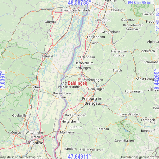
Bahlingen GPS coordinates[2]
48° 7' 14.304" North, 7° 44' 23.352" East
| Map corner | latitude | longitude |
|---|---|---|
| Upper-left | 48.58788°, | 7.0367° |
| Center: | 48.12064°, | 7.73982° |
| Lower-right: | 47.64911°, | 8.44295° |
| Map W x H: | 104.4×104.4 km | = 64.9×64.9mi |
| max Lat: | 55.01917° ⇑93.7% North |
| Bahlingen: | 48.12064° |
| min Lat: | ⇓6.3% South 47.40724° |
| min Long | Bahlingen | max Long |
| 5.92978° | 7.73982° | 14.98853° |
| W 17.7%⇐ | ⇒82.3% E |
Elevation
Elevation of Bahlingen is 188 m = 617 ft, and this is 61.1 m = 200 ft below average elevation for this country.
| Max E: |
1256 m = 4121 ft | 55% |
| Avg. | 249.1 m = 817 ft | |
| Bahlingen | 188 m = 617 ft | |
Min E: |
-5 m = -16 ft | 45% |
See also: Germany elevation on elevation.city.
Geographical zone
Bahlingen is located in North temperate zone (between Tropic of Cancer and the Arctic Circle). Distance of this North polar circle is 2050.7 km =1274.2 mi to North.| Distance of | km | miles | from Bahlingen |
|---|---|---|---|
| North Pole | 4656.5 | 2893.4 | to North |
| Arctic Circle | 2050.7 | 1274.2 | to North |
| Tropic Cancer | 2744.6 | 1705.4 | to South |
| Equator | 5350.5 | 3324.6 | to South |


Nearby cities:
15 places around Bahlingen: (largest is in red/bold)
• Bischoffingen
8.6 km =5.3 mi,  257°
257°
• Buchheim
7.2 km =4.5 mi,  160°
160°
• Bötzingen
5 km =3.1 mi,  192°
192°
• Eichstetten
2.9 km =1.8 mi,  176°
176°
• Emmendingen
8.4 km =5.2 mi,  89°
89°
• Endingen
3.8 km =2.4 mi,  309°
309°
• Forchheim
5.9 km =3.7 mi,  330°
330°
• Gottenheim
7.9 km =4.9 mi, 183°
• Kenzingen
8.7 km =5.4 mi,  14°
14°
• Malterdingen
5.3 km =3.3 mi,  40°
40°
• Oberrotweil
8.4 km =5.2 mi,  246°
246°
• Riegel
3.5 km =2.2 mi, 11°
• Teningen
5.5 km =3.4 mi,  79°
79°
• Vogtsburg
7.7 km =4.8 mi, 250°
• Wyhl
8.4 km =5.2 mi, 306°
Sources, notices
• [Note1] Compared only with cities in Germany existing in our database
• [Src1] Map data: © OpenStreetMap contributors (CC-BY-SA)
• [Src2] Other city data from geonames.org with taken over terms of usage.
• [Src3] Geographical zone / Annual Mean Temperature by Robert A. Rohde @ Wikipedia
