Troisdorf geodata
Troisdorf (North Rhine-Westphalia) is a populated place; located in Germany in Europe/Berlin (GMT+2) time zone. With population of 74,749 people, there are 140 cities with bigger population in this country. Compared to other cities in Germany, 54.3% of cities are located further ↓South; 91.9% of cities are located further →East and 77.3% of cities have higher elevation than Troisdorf. Note1
Administrative division(s):
- Level 1: North Rhine-Westphalia
- Level 2: Regierungsbezirk Köln
- Level 3: Rhein-Sieg-Kreis
- Level 4: Troisdorf


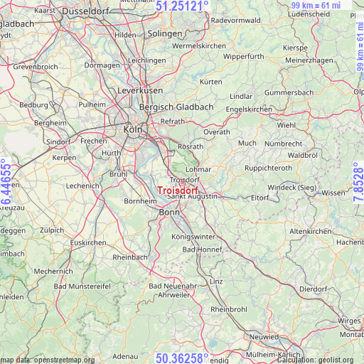
Troisdorf GPS coordinates[2]
50° 48' 32.436" North, 7° 8' 58.848" East
| Map corner | latitude | longitude |
|---|---|---|
| Upper-left | 51.25121°, | 6.44655° |
| Center: | 50.80901°, | 7.14968° |
| Lower-right: | 50.36258°, | 7.8528° |
| Map W x H: | 98.8×98.8 km | = 61.4×61.4mi |
| max Lat: | 55.01917° ⇑45.7% North |
| Troisdorf: | 50.80901° |
| min Lat: | ⇓54.3% South 47.40724° |
| min Long | Troisdorf | max Long |
| 5.92978° | 7.14968° | 14.98853° |
| W 8.1%⇐ | ⇒91.9% E |
Elevation
Elevation of Troisdorf is 55 m = 180 ft, and this is 194.1 m = 637 ft below average elevation for this country.
| Max E: |
1256 m = 4121 ft | 77.3% |
| Avg. | 249.1 m = 817 ft | |
| Troisdorf | 55 m = 180 ft | |
Min E: |
-5 m = -16 ft | 22.7% |
See also: Troisdorf elevation on elevation.city.
Geographical zone
Troisdorf is located in North temperate zone (between Tropic of Cancer and the Arctic Circle). Distance of this North polar circle is 1751.7 km =1088.5 mi to North.| Distance of | km | miles | from Troisdorf |
|---|---|---|---|
| North Pole | 4357.6 | 2707.7 | to North |
| Arctic Circle | 1751.7 | 1088.5 | to North |
| Tropic Cancer | 3043.5 | 1891.1 | to South |
| Equator | 5649.4 | 3510.4 | to South |


Nearby cities:
15 places around Troisdorf: (largest is in red/bold)
• Alfter
12.6 km =7.8 mi,  228°
228°
• Bonn
9.1 km =5.7 mi,  204°
204°
• Bornheim
12.3 km =7.6 mi,  245°
245°
• Eil
10.6 km =6.6 mi,  332°
332°
• Gremberghoven
12 km =7.5 mi, 328°
• Hennef
10.1 km =6.3 mi,  111°
111°
• Lohmar
5.6 km =3.5 mi,  53°
53°
• Niederkassel
7.9 km =4.9 mi,  274°
274°
• Porz am Rhein
10.7 km =6.6 mi,  323°
323°
• Rösrath
9.9 km =6.2 mi,  13°
13°
• Sankt Augustin
5 km =3.1 mi,  138°
138°
• Siegburg
4.2 km =2.6 mi,  103°
103°
• Stoßdorf
7.7 km =4.8 mi, 112°
• Wahn-Heide
6.3 km =3.9 mi, 331°
• Wesseling
12.5 km =7.8 mi,  279°
279°
Sources, notices
• [Note1] Compared only with cities in Germany existing in our database
• [Src1] Map data: © OpenStreetMap contributors (CC-BY-SA)
• [Src2] Other city data from geonames.org with taken over terms of usage.
• [Src3] Geographical zone / Annual Mean Temperature by Robert A. Rohde @ Wikipedia
