Bonn geodata
Bonn (North Rhine-Westphalia) is a seat of a third-order administrative division; located in Germany in Europe/Berlin (GMT+2) time zone. With population of 313,125 people, there are 20 cities with bigger population in this country. Compared to other cities in Germany, 53% of cities are located further ↓South; 92.4% of cities are located further →East and 74.7% of cities have higher elevation than Bonn. Note1
Administrative division(s):
- Level 1: North Rhine-Westphalia
- Level 2: Regierungsbezirk Köln
- Level 3: Kreisfreie Stadt Bonn
- Level 4: Bonn


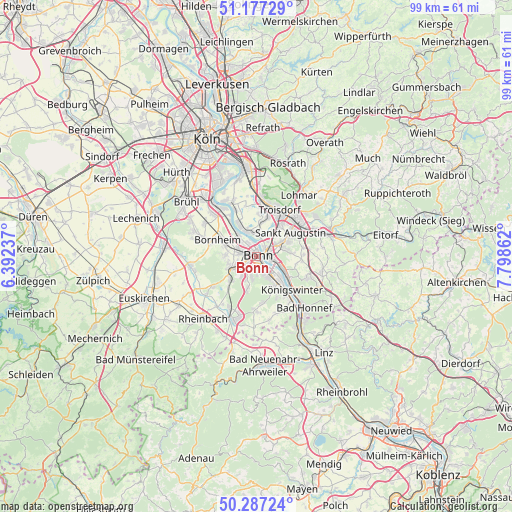
Bonn GPS coordinates[2]
50° 44' 3.768" North, 7° 5' 43.764" East
| Map corner | latitude | longitude |
|---|---|---|
| Upper-left | 51.17729°, | 6.39237° |
| Center: | 50.73438°, | 7.09549° |
| Lower-right: | 50.28724°, | 7.79862° |
| Map W x H: | 99×99 km | = 61.5×61.5mi |
| max Lat: | 55.01917° ⇑47% North |
| Bonn: | 50.73438° |
| min Lat: | ⇓53% South 47.40724° |
| min Long | Bonn | max Long |
| 5.92978° | 7.09549° | 14.98853° |
| W 7.6%⇐ | ⇒92.4% E |
Elevation
Elevation of Bonn is 64 m = 210 ft, and this is 185.1 m = 607 ft below average elevation for this country.
| Max E: |
1256 m = 4121 ft | 74.7% |
| Avg. | 249.1 m = 817 ft | |
| Bonn | 64 m = 210 ft | |
Min E: |
-5 m = -16 ft | 25.3% |
See also: Bonn elevation on elevation.city.
Geographical zone
Bonn is located in North temperate zone (between Tropic of Cancer and the Arctic Circle). Distance of this North polar circle is 1760 km =1093.6 mi to North.| Distance of | km | miles | from Bonn |
|---|---|---|---|
| North Pole | 4365.9 | 2712.8 | to North |
| Arctic Circle | 1760 | 1093.6 | to North |
| Tropic Cancer | 3035.2 | 1886 | to South |
| Equator | 5641.1 | 3505.2 | to South |


Nearby cities:
15 places around Bonn: (largest is in red/bold)
• Alfter
5.5 km =3.4 mi,  268°
268°
• Bad Honnef
13.8 km =8.6 mi,  137°
137°
• Bornheim
8 km =5 mi,  293°
293°
• Boseroth
13.3 km =8.3 mi,  105°
105°
• Hennef
14 km =8.7 mi,  70°
70°
• Königswinter
8.5 km =5.3 mi,  131°
131°
• Meckenheim
13.1 km =8.1 mi,  200°
200°
• Niederkassel
9.8 km =6.1 mi,  335°
335°
• Sankt Augustin
8.5 km =5.3 mi,  57°
57°
• Siegburg
10.8 km =6.7 mi,  47°
47°
• Stoßdorf
12.2 km =7.6 mi, 63°
• Troisdorf
9.1 km =5.7 mi,  24°
24°
• Wachtberg
11.2 km =7 mi,  178°
178°
• Wahn-Heide
13.9 km =8.6 mi,  3°
3°
• Wesseling
13.4 km =8.3 mi,  320°
320°
Sources, notices
• [Note1] Compared only with cities in Germany existing in our database
• [Src1] Map data: © OpenStreetMap contributors (CC-BY-SA)
• [Src2] Other city data from geonames.org with taken over terms of usage.
• [Src3] Geographical zone / Annual Mean Temperature by Robert A. Rohde @ Wikipedia
