Hennef geodata
Hennef (North Rhine-Westphalia) is a seat of a fourth-order administrative division; located in Germany in Europe/Berlin (GMT+2) time zone. With population of 45,409 people, there are 261 cities with bigger population in this country. Compared to other cities in Germany, 53.7% of cities are located further ↓South; 90.3% of cities are located further →East and 73.4% of cities have higher elevation than Hennef. Note1
Administrative division(s):
- Level 1: North Rhine-Westphalia
- Level 2: Regierungsbezirk Köln
- Level 3: Rhein-Sieg-Kreis
- Level 4: Hennef (Sieg)


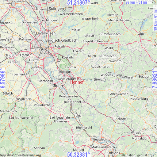
Hennef GPS coordinates[2]
50° 46' 31.98" North, 7° 16' 59.088" East
| Map corner | latitude | longitude |
|---|---|---|
| Upper-left | 51.21807°, | 6.57996° |
| Center: | 50.77555°, | 7.28308° |
| Lower-right: | 50.32881°, | 7.98621° |
| Map W x H: | 98.9×98.9 km | = 61.5×61.5mi |
| max Lat: | 55.01917° ⇑46.3% North |
| Hennef: | 50.77555° |
| min Lat: | ⇓53.7% South 47.40724° |
| min Long | Hennef | max Long |
| 5.92978° | 7.28308° | 14.98853° |
| W 9.7%⇐ | ⇒90.3% E |
Elevation
Elevation of Hennef is 70 m = 230 ft, and this is 179.1 m = 588 ft below average elevation for this country.
| Max E: |
1256 m = 4121 ft | 73.4% |
| Avg. | 249.1 m = 817 ft | |
| Hennef | 70 m = 230 ft | |
Min E: |
-5 m = -16 ft | 26.6% |
See also: Hennef elevation on elevation.city.
Geographical zone
Hennef is located in North temperate zone (between Tropic of Cancer and the Arctic Circle). Distance of this North polar circle is 1755.5 km =1090.8 mi to North.| Distance of | km | miles | from Hennef |
|---|---|---|---|
| North Pole | 4361.4 | 2710 | to North |
| Arctic Circle | 1755.5 | 1090.8 | to North |
| Tropic Cancer | 3039.8 | 1888.8 | to South |
| Equator | 5645.7 | 3508.1 | to South |


Nearby cities:
15 places around Hennef: (largest is in red/bold)
• Asbach
15.3 km =9.5 mi,  142°
142°
• Bad Honnef
15.2 km =9.4 mi,  194°
194°
• Bonn
14 km =8.7 mi,  250°
250°
• Boseroth
8.2 km =5.1 mi,  183°
183°
• Eitorf
11.8 km =7.3 mi,  94°
94°
• Kircheib
14.4 km =8.9 mi,  120°
120°
• Königswinter
12.3 km =7.6 mi,  213°
213°
• Lohmar
8.5 km =5.3 mi,  325°
325°
• Rösrath
15.1 km =9.4 mi, 331°
• Sankt Augustin
6.1 km =3.8 mi,  269°
269°
• Siegburg
6 km =3.7 mi,  297°
297°
• Stoßdorf
2.4 km =1.5 mi,  289°
289°
• Troisdorf
10.1 km =6.3 mi, 291°
• Wahn-Heide
15.5 km =9.6 mi,  306°
306°
• Windhagen
15.7 km =9.8 mi,  161°
161°
Sources, notices
• [Note1] Compared only with cities in Germany existing in our database
• [Src1] Map data: © OpenStreetMap contributors (CC-BY-SA)
• [Src2] Other city data from geonames.org with taken over terms of usage.
• [Src3] Geographical zone / Annual Mean Temperature by Robert A. Rohde @ Wikipedia
