Bornheim geodata
Bornheim (North Rhine-Westphalia) is a populated place; located in Germany in Europe/Berlin (GMT+2) time zone. With population of 48,523 people, there are 238 cities with bigger population in this country. Compared to other cities in Germany, 53.5% of cities are located further ↓South; 93.5% of cities are located further →East and 75.3% of cities have higher elevation than Bornheim. Note1
Administrative division(s):
- Level 1: North Rhine-Westphalia
- Level 2: Regierungsbezirk Köln
- Level 3: Rhein-Sieg-Kreis
- Level 4: Bornheim


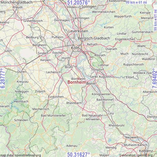
Bornheim GPS coordinates[2]
50° 45' 47.268" North, 6° 59' 27.204" East
| Map corner | latitude | longitude |
|---|---|---|
| Upper-left | 51.20576°, | 6.28777° |
| Center: | 50.76313°, | 6.99089° |
| Lower-right: | 50.31627°, | 7.69402° |
| Map W x H: | 98.9×98.9 km | = 61.5×61.5mi |
| max Lat: | 55.01917° ⇑46.5% North |
| Bornheim: | 50.76313° |
| min Lat: | ⇓53.5% South 47.40724° |
| min Long | Bornheim | max Long |
| 5.92978° | 6.99089° | 14.98853° |
| W 6.5%⇐ | ⇒93.5% E |
Elevation
Elevation of Bornheim is 62 m = 203 ft, and this is 187.1 m = 614 ft below average elevation for this country.
| Max E: |
1256 m = 4121 ft | 75.3% |
| Avg. | 249.1 m = 817 ft | |
| Bornheim | 62 m = 203 ft | |
Min E: |
-5 m = -16 ft | 24.7% |
See also: Bornheim elevation on elevation.city.
Geographical zone
Bornheim is located in North temperate zone (between Tropic of Cancer and the Arctic Circle). Distance of this North polar circle is 1756.8 km =1091.6 mi to North.| Distance of | km | miles | from Bornheim |
|---|---|---|---|
| North Pole | 4362.7 | 2710.9 | to North |
| Arctic Circle | 1756.8 | 1091.6 | to North |
| Tropic Cancer | 3038.4 | 1888 | to South |
| Equator | 5644.3 | 3507.2 | to South |


Nearby cities:
15 places around Bornheim: (largest is in red/bold)
• Alfter
3.8 km =2.4 mi,  151°
151°
• Bonn
8 km =5 mi,  113°
113°
• Brühl
9.5 km =5.9 mi,  320°
320°
• Eil
15.8 km =9.8 mi,  23°
23°
• Erftstadt
15 km =9.3 mi,  292°
292°
• Hürth
14.8 km =9.2 mi, 324°
• Meckenheim
15.7 km =9.8 mi,  170°
170°
• Niederkassel
6.6 km =4.1 mi,  29°
29°
• Porz am Rhein
14.5 km =9 mi, 19°
• Rheinbach
15.6 km =9.7 mi,  190°
190°
• Sankt Augustin
14.6 km =9.1 mi,  84°
84°
• Troisdorf
12.3 km =7.6 mi,  65°
65°
• Wahn-Heide
13.4 km =8.3 mi,  37°
37°
• Weilerswist
10.3 km =6.4 mi,  263°
263°
• Wesseling
7.2 km =4.5 mi,  350°
350°
Sources, notices
• [Note1] Compared only with cities in Germany existing in our database
• [Src1] Map data: © OpenStreetMap contributors (CC-BY-SA)
• [Src2] Other city data from geonames.org with taken over terms of usage.
• [Src3] Geographical zone / Annual Mean Temperature by Robert A. Rohde @ Wikipedia
