Sankt Augustin geodata
Sankt Augustin (North Rhine-Westphalia) is a populated place; located in Germany in Europe/Berlin (GMT+2) time zone. With population of 56,094 people, there are 191 cities with bigger population in this country. Compared to other cities in Germany, 53.7% of cities are located further ↓South; 91.4% of cities are located further →East and 73.6% of cities have higher elevation than Sankt Augustin. Note1
Administrative division(s):
- Level 1: North Rhine-Westphalia
- Level 2: Regierungsbezirk Köln
- Level 3: Rhein-Sieg-Kreis
- Level 4: Sankt Augustin


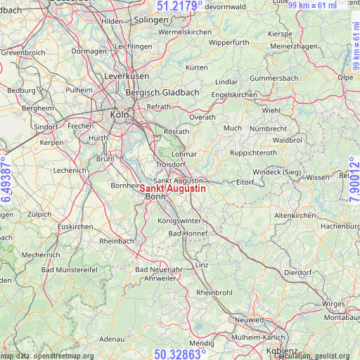
Sankt Augustin GPS coordinates[2]
50° 46' 31.368" North, 7° 11' 49.2" East
| Map corner | latitude | longitude |
|---|---|---|
| Upper-left | 51.2179°, | 6.49387° |
| Center: | 50.77538°, | 7.197° |
| Lower-right: | 50.32863°, | 7.90012° |
| Map W x H: | 98.9×98.9 km | = 61.5×61.5mi |
| max Lat: | 55.01917° ⇑46.3% North |
| Sankt Augustin: | 50.77538° |
| min Lat: | ⇓53.7% South 47.40724° |
| min Long | Sankt Augustin | max Long |
| 5.92978° | 7.197° | 14.98853° |
| W 8.6%⇐ | ⇒91.4% E |
Elevation
Elevation of Sankt Augustin is 69 m = 226 ft, and this is 180.1 m = 591 ft below average elevation for this country.
| Max E: |
1256 m = 4121 ft | 73.6% |
| Avg. | 249.1 m = 817 ft | |
| Sankt Augustin | 69 m = 226 ft | |
Min E: |
-5 m = -16 ft | 26.4% |
See also: Sankt Augustin elevation on elevation.city.
Geographical zone
Sankt Augustin is located in North temperate zone (between Tropic of Cancer and the Arctic Circle). Distance of this North polar circle is 1755.5 km =1090.8 mi to North.| Distance of | km | miles | from Sankt Augustin |
|---|---|---|---|
| North Pole | 4361.4 | 2710 | to North |
| Arctic Circle | 1755.5 | 1090.8 | to North |
| Tropic Cancer | 3039.8 | 1888.8 | to South |
| Equator | 5645.7 | 3508.1 | to South |


Nearby cities:
15 places around Sankt Augustin: (largest is in red/bold)
• Alfter
13.5 km =8.4 mi,  249°
249°
• Bad Honnef
14.8 km =9.2 mi,  171°
171°
• Bonn
8.5 km =5.3 mi,  237°
237°
• Bornheim
14.6 km =9.1 mi,  264°
264°
• Boseroth
9.9 km =6.2 mi,  145°
145°
• Eil
15.5 km =9.6 mi,  327°
327°
• Hennef
6.1 km =3.8 mi,  89°
89°
• Königswinter
10.2 km =6.3 mi,  184°
184°
• Lohmar
7.1 km =4.4 mi,  9°
9°
• Niederkassel
12 km =7.5 mi,  291°
291°
• Rösrath
13.4 km =8.3 mi,  355°
355°
• Siegburg
2.9 km =1.8 mi,  15°
15°
• Stoßdorf
3.9 km =2.4 mi,  78°
78°
• Troisdorf
5 km =3.1 mi,  318°
318°
• Wahn-Heide
11.3 km =7 mi, 325°
Sources, notices
• [Note1] Compared only with cities in Germany existing in our database
• [Src1] Map data: © OpenStreetMap contributors (CC-BY-SA)
• [Src2] Other city data from geonames.org with taken over terms of usage.
• [Src3] Geographical zone / Annual Mean Temperature by Robert A. Rohde @ Wikipedia
