Reuth geodata
Reuth (Saxony) is a seat of a fourth-order administrative division; located in Germany in Europe/Berlin (GMT+2) time zone. In our database, there are 11009 cities with bigger population. Compared to other cities in Germany, 53.4% of cities are located further ↑North; 81.3% of cities are located further ←West and 93.6% of cities have lower elevation than Reuth. Note1


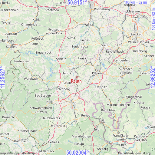
Reuth GPS coordinates[2]
50° 28' 10.884" North, 11° 57' 33.804" East
| Map corner | latitude | longitude |
|---|---|---|
| Upper-left | 50.9151°, | 11.25627° |
| Center: | 50.46969°, | 11.95939° |
| Lower-right: | 50.02004°, | 12.66252° |
| Map W x H: | 99.5×99.5 km | = 61.8×61.8mi |
| max Lat: | 55.01917° ⇑53.4% North |
| Reuth: | 50.46969° |
| min Lat: | ⇓46.6% South 47.40724° |
| min Long | Reuth | max Long |
| 5.92978° | 11.95939° | 14.98853° |
| W 81.3%⇐ | ⇒18.7% E |
Elevation
Elevation of Reuth is 568 m = 1864 ft, and this is 318.9 m = 1046 ft above average elevation for this country.
| Max E: |
1256 m = 4121 ft | 6.4% |
| Reuth | 568 m 1864 ft | |
| Avg. | 249.1 m = 817 ft | |
Min E: |
-5 m = -16 ft | 93.6% |
See also: Germany elevation on elevation.city.
Geographical zone
Reuth is located in North temperate zone (between Tropic of Cancer and the Arctic Circle). Distance of this North polar circle is 1789.5 km =1111.9 mi to North.| Distance of | km | miles | from Reuth |
|---|---|---|---|
| North Pole | 4395.4 | 2731.2 | to North |
| Arctic Circle | 1789.5 | 1111.9 | to North |
| Tropic Cancer | 3005.8 | 1867.7 | to South |
| Equator | 5611.7 | 3486.9 | to South |


Nearby cities:
15 places around Reuth: (largest is in red/bold)
• Birkenhügel
15.4 km =9.6 mi,  254°
254°
• Bösenbrunn
12.8 km =8 mi,  129°
129°
• Feilitzsch
11.6 km =7.2 mi,  189°
189°
• Kirschkau
15.9 km =9.9 mi,  341°
341°
• Mehltheuer
10 km =6.2 mi,  33°
33°
• Mühltroff
8 km =5 mi, 344°
• Oelsnitz
16.1 km =10 mi,  112°
112°
• Pausa
12.7 km =7.9 mi,  12°
12°
• Plauen
13 km =8.1 mi,  76°
76°
• Syrau
11.8 km =7.3 mi,  46°
46°
• Tanna
7.7 km =4.8 mi,  290°
290°
• Triebel
15.8 km =9.8 mi, 133°
• Trogen
11.5 km =7.1 mi,  183°
183°
• Töpen
10.7 km =6.6 mi,  214°
214°
• Weischlitz
7.9 km =4.9 mi, 106°
Sources, notices
• [Note1] Compared only with cities in Germany existing in our database
• [Src1] Map data: © OpenStreetMap contributors (CC-BY-SA)
• [Src2] Other city data from geonames.org with taken over terms of usage.
• [Src3] Geographical zone / Annual Mean Temperature by Robert A. Rohde @ Wikipedia
