Tanna geodata
Tanna (Thuringia) is a populated place; located in Germany in Europe/Berlin (GMT+2) time zone. With population of 4,193 people, there are 3179 cities with bigger population in this country. Compared to other cities in Germany, 52.9% of cities are located further ↑North; 79.6% of cities are located further ←West and 92.5% of cities have lower elevation than Tanna. Note1


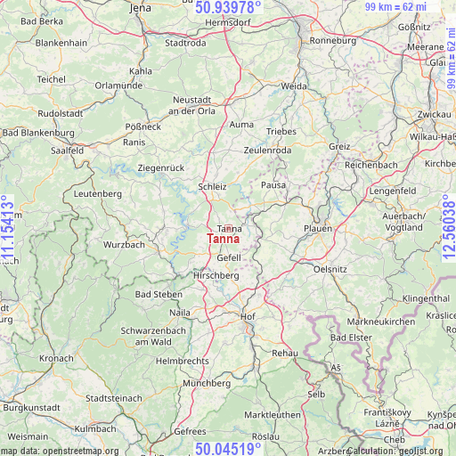
Tanna GPS coordinates[2]
50° 29' 40.56" North, 11° 51' 26.1" East
| Map corner | latitude | longitude |
|---|---|---|
| Upper-left | 50.93978°, | 11.15413° |
| Center: | 50.4946°, | 11.85725° |
| Lower-right: | 50.04519°, | 12.56038° |
| Map W x H: | 99.5×99.5 km | = 61.8×61.8mi |
| max Lat: | 55.01917° ⇑52.9% North |
| Tanna: | 50.4946° |
| min Lat: | ⇓47.1% South 47.40724° |
| min Long | Tanna | max Long |
| 5.92978° | 11.85725° | 14.98853° |
| W 79.6%⇐ | ⇒20.4% E |
Elevation
Elevation of Tanna is 551 m = 1808 ft, and this is 301.9 m = 990 ft above average elevation for this country.
| Max E: |
1256 m = 4121 ft | 7.5% |
| Tanna | 551 m 1808 ft | |
| Avg. | 249.1 m = 817 ft | |
Min E: |
-5 m = -16 ft | 92.5% |
See also: Germany elevation on elevation.city.
Geographical zone
Tanna is located in North temperate zone (between Tropic of Cancer and the Arctic Circle). Distance of this North polar circle is 1786.7 km =1110.2 mi to North.| Distance of | km | miles | from Tanna |
|---|---|---|---|
| North Pole | 4392.6 | 2729.4 | to North |
| Arctic Circle | 1786.7 | 1110.2 | to North |
| Tropic Cancer | 3008.6 | 1869.5 | to South |
| Equator | 5614.5 | 3488.7 | to South |


Nearby cities:
15 places around Tanna: (largest is in red/bold)
• Birkenhügel
10.2 km =6.3 mi,  228°
228°
• Burgk
12 km =7.5 mi,  304°
304°
• Crispendorf
13.9 km =8.6 mi,  320°
320°
• Görkwitz
11.2 km =7 mi,  332°
332°
• Kirschkau
12.4 km =7.7 mi,  9°
9°
• Löhma
13 km =8.1 mi,  358°
358°
• Mehltheuer
13.9 km =8.6 mi,  66°
66°
• Mühltroff
7.1 km =4.4 mi,  45°
45°
• Oettersdorf
12.1 km =7.5 mi,  346°
346°
• Pausa
13.8 km =8.6 mi, 45°
• Pottiga
12.1 km =7.5 mi,  222°
222°
• Pörmitz
13.9 km =8.6 mi, 348°
• Reuth
7.7 km =4.8 mi,  110°
110°
• Schleiz
9.9 km =6.2 mi,  340°
340°
• Töpen
11.6 km =7.2 mi,  174°
174°
Sources, notices
• [Note1] Compared only with cities in Germany existing in our database
• [Src1] Map data: © OpenStreetMap contributors (CC-BY-SA)
• [Src2] Other city data from geonames.org with taken over terms of usage.
• [Src3] Geographical zone / Annual Mean Temperature by Robert A. Rohde @ Wikipedia
