Gattendorf geodata
Gattendorf (Bavaria) is a seat of a fourth-order administrative division; located in Germany in Europe/Berlin (GMT+2) time zone. With population of 1,217 people, there are 6517 cities with bigger population in this country. Compared to other cities in Germany, 56.2% of cities are located further ↑North; 81.7% of cities are located further ←West and 93% of cities have lower elevation than Gattendorf. Note1
Administrative division(s):
- Level 1: Bavaria
- Level 2: Upper Franconia
- Level 3: Landkreis Hof
- Level 4: Gattendorf


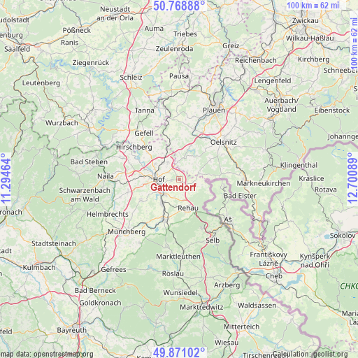
Gattendorf GPS coordinates[2]
50° 19' 19.452" North, 11° 59' 51.936" East
| Map corner | latitude | longitude |
|---|---|---|
| Upper-left | 50.76888°, | 11.29464° |
| Center: | 50.32207°, | 11.99776° |
| Lower-right: | 49.87102°, | 12.70089° |
| Map W x H: | 99.8×99.8 km | = 62×62mi |
| max Lat: | 55.01917° ⇑56.2% North |
| Gattendorf: | 50.32207° |
| min Lat: | ⇓43.8% South 47.40724° |
| min Long | Gattendorf | max Long |
| 5.92978° | 11.99776° | 14.98853° |
| W 81.7%⇐ | ⇒18.3% E |
Elevation
Elevation of Gattendorf is 557 m = 1827 ft, and this is 307.9 m = 1010 ft above average elevation for this country.
| Max E: |
1256 m = 4121 ft | 7% |
| Gattendorf | 557 m 1827 ft | |
| Avg. | 249.1 m = 817 ft | |
Min E: |
-5 m = -16 ft | 93% |
See also: Germany elevation on elevation.city.
Geographical zone
Gattendorf is located in North temperate zone (between Tropic of Cancer and the Arctic Circle). Distance of this North polar circle is 1805.9 km =1122.1 mi to North.| Distance of | km | miles | from Gattendorf |
|---|---|---|---|
| North Pole | 4411.8 | 2741.4 | to North |
| Arctic Circle | 1805.9 | 1122.1 | to North |
| Tropic Cancer | 2989.4 | 1857.5 | to South |
| Equator | 5595.3 | 3476.8 | to South |


Nearby cities:
15 places around Gattendorf: (largest is in red/bold)
• Bösenbrunn
11 km =6.8 mi,  41°
41°
• Döhlau
5.5 km =3.4 mi,  218°
218°
• Eichigt
12.4 km =7.7 mi,  75°
75°
• Feilitzsch
6.7 km =4.2 mi,  317°
317°
• Haag
5.9 km =3.7 mi,  110°
110°
• Hof
6.1 km =3.8 mi,  260°
260°
• Konradsreuth
12.2 km =7.6 mi,  239°
239°
• Köditz
10.6 km =6.6 mi,  276°
276°
• Oberkotzau
8 km =5 mi,  213°
213°
• Regnitzlosau
4.4 km =2.7 mi,  123°
123°
• Rehau
8.5 km =5.3 mi,  162°
162°
• Schwarzenbach an der Saale
11.9 km =7.4 mi,  201°
201°
• Triebel
10.3 km =6.4 mi,  57°
57°
• Trogen
6 km =3.7 mi,  325°
325°
• Töpen
11.7 km =7.3 mi,  310°
310°
Sources, notices
• [Note1] Compared only with cities in Germany existing in our database
• [Src1] Map data: © OpenStreetMap contributors (CC-BY-SA)
• [Src2] Other city data from geonames.org with taken over terms of usage.
• [Src3] Geographical zone / Annual Mean Temperature by Robert A. Rohde @ Wikipedia
