Tecklenburg geodata
Tecklenburg (North Rhine-Westphalia) is a populated place; located in Germany in Europe/Berlin (GMT+2) time zone. With population of 9,552 people, there are 1695 cities with bigger population in this country. Compared to other cities in Germany, 74.3% of cities are located further ↓South; 80.8% of cities are located further →East and 57.4% of cities have higher elevation than Tecklenburg. Note1
Administrative division(s):
- Level 1: North Rhine-Westphalia
- Level 2: Regierungsbezirk Münster
- Level 3: Kreis Steinfurt
- Level 4: Tecklenburg


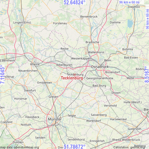
Tecklenburg GPS coordinates[2]
52° 13' 10.452" North, 7° 48' 48.852" East
| Map corner | latitude | longitude |
|---|---|---|
| Upper-left | 52.64824°, | 7.11045° |
| Center: | 52.21957°, | 7.81357° |
| Lower-right: | 51.78672°, | 8.5167° |
| Map W x H: | 95.8×95.8 km | = 59.5×59.5mi |
| max Lat: | 55.01917° ⇑25.7% North |
| Tecklenburg: | 52.21957° |
| min Lat: | ⇓74.3% South 47.40724° |
| min Long | Tecklenburg | max Long |
| 5.92978° | 7.81357° | 14.98853° |
| W 19.2%⇐ | ⇒80.8% E |
Elevation
Elevation of Tecklenburg is 172 m = 564 ft, and this is 77.1 m = 253 ft below average elevation for this country.
| Max E: |
1256 m = 4121 ft | 57.4% |
| Avg. | 249.1 m = 817 ft | |
| Tecklenburg | 172 m = 564 ft | |
Min E: |
-5 m = -16 ft | 42.6% |
See also: Germany elevation on elevation.city.
Geographical zone
Tecklenburg is located in North temperate zone (between Tropic of Cancer and the Arctic Circle). Distance of this North polar circle is 1594.9 km =991 mi to North.| Distance of | km | miles | from Tecklenburg |
|---|---|---|---|
| North Pole | 4200.8 | 2610.3 | to North |
| Arctic Circle | 1594.9 | 991 | to North |
| Tropic Cancer | 3200.4 | 1988.6 | to South |
| Equator | 5806.3 | 3607.9 | to South |


Nearby cities:
15 places around Tecklenburg: (largest is in red/bold)
• Bad Iburg
17.2 km =10.7 mi,  114°
114°
• Birgte
11.7 km =7.3 mi,  285°
285°
• Georgsmarienhütte
15.9 km =9.9 mi,  96°
96°
• Hagen
11.7 km =7.3 mi, 102°
• Hasbergen
10.2 km =6.3 mi,  78°
78°
• Ibbenbüren
9.5 km =5.9 mi,  314°
314°
• Ladbergen
10.5 km =6.5 mi,  204°
204°
• Lengerich
4.9 km =3 mi,  138°
138°
• Lienen
13.9 km =8.6 mi,  123°
123°
• Lotte
10 km =6.2 mi,  44°
44°
• Mettingen
11 km =6.8 mi,  349°
349°
• Osnabrück
17.1 km =10.6 mi,  69°
69°
• Recke
17.7 km =11 mi,  339°
339°
• Saerbeck
13.3 km =8.3 mi,  247°
247°
• Westerkappeln
11.8 km =7.3 mi,  23°
23°
Sources, notices
• [Note1] Compared only with cities in Germany existing in our database
• [Src1] Map data: © OpenStreetMap contributors (CC-BY-SA)
• [Src2] Other city data from geonames.org with taken over terms of usage.
• [Src3] Geographical zone / Annual Mean Temperature by Robert A. Rohde @ Wikipedia
