Hagen geodata
Hagen (Lower Saxony) is a populated place; located in Germany in Europe/Berlin (GMT+2) time zone. With population of 14,187 people, there are 1122 cities with bigger population in this country. Compared to other cities in Germany, 74% of cities are located further ↓South; 77.5% of cities are located further →East and 66.9% of cities have higher elevation than Hagen. Note1
Administrative division(s):
- Level 1: Lower Saxony
- Level 3: Landkreis Osnabrück
- Level 4: Hagen am Teutoburger Wald


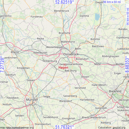
Hagen GPS coordinates[2]
52° 11' 46.644" North, 7° 58' 49.476" East
| Map corner | latitude | longitude |
|---|---|---|
| Upper-left | 52.62519°, | 7.27728° |
| Center: | 52.19629°, | 7.98041° |
| Lower-right: | 51.76321°, | 8.68353° |
| Map W x H: | 95.8×95.8 km | = 59.5×59.5mi |
| max Lat: | 55.01917° ⇑26% North |
| Hagen: | 52.19629° |
| min Lat: | ⇓74% South 47.40724° |
| min Long | Hagen | max Long |
| 5.92978° | 7.98041° | 14.98853° |
| W 22.5%⇐ | ⇒77.5% E |
Elevation
Elevation of Hagen is 109 m = 358 ft, and this is 140.1 m = 460 ft below average elevation for this country.
| Max E: |
1256 m = 4121 ft | 66.9% |
| Avg. | 249.1 m = 817 ft | |
| Hagen | 109 m = 358 ft | |
Min E: |
-5 m = -16 ft | 33.1% |
See also: Germany elevation on elevation.city.
Geographical zone
Hagen is located in North temperate zone (between Tropic of Cancer and the Arctic Circle). Distance of this North polar circle is 1597.5 km =992.6 mi to North.| Distance of | km | miles | from Hagen |
|---|---|---|---|
| North Pole | 4203.4 | 2611.9 | to North |
| Arctic Circle | 1597.5 | 992.6 | to North |
| Tropic Cancer | 3197.8 | 1987 | to South |
| Equator | 5803.7 | 3606.3 | to South |


Nearby cities:
15 places around Hagen: (largest is in red/bold)
• Bad Iburg
6.2 km =3.9 mi,  137°
137°
• Bad Laer
12.8 km =8 mi,  146°
146°
• Bad Rothenfelde
15.5 km =9.6 mi,  124°
124°
• Belm
15.5 km =9.6 mi,  42°
42°
• Bissendorf
13.3 km =8.3 mi,  72°
72°
• Georgsmarienhütte
4.5 km =2.8 mi,  80°
80°
• Glandorf
12.5 km =7.8 mi,  174°
174°
• Hasbergen
4.8 km =3 mi,  344°
344°
• Hilter
13.2 km =8.2 mi, 120°
• Lengerich
8.2 km =5.1 mi,  262°
262°
• Lienen
5.2 km =3.2 mi,  177°
177°
• Lotte
10.6 km =6.6 mi, 335°
• Osnabrück
9.7 km =6 mi,  29°
29°
• Tecklenburg
11.7 km =7.3 mi,  282°
282°
• Westerkappeln
14.9 km =9.3 mi,  333°
333°
Sources, notices
• [Note1] Compared only with cities in Germany existing in our database
• [Src1] Map data: © OpenStreetMap contributors (CC-BY-SA)
• [Src2] Other city data from geonames.org with taken over terms of usage.
• [Src3] Geographical zone / Annual Mean Temperature by Robert A. Rohde @ Wikipedia
