Georgsmarienhütte geodata
Georgsmarienhütte (Lower Saxony) is a populated place; located in Germany in Europe/Berlin (GMT+2) time zone. With population of 32,580 people, there are 422 cities with bigger population in this country. Compared to other cities in Germany, 74.1% of cities are located further ↓South; 76.4% of cities are located further →East and 65.6% of cities have higher elevation than Georgsmarienhütte. Note1
Administrative division(s):
- Level 1: Lower Saxony
- Level 3: Landkreis Osnabrück
- Level 4: Georgsmarienhütte


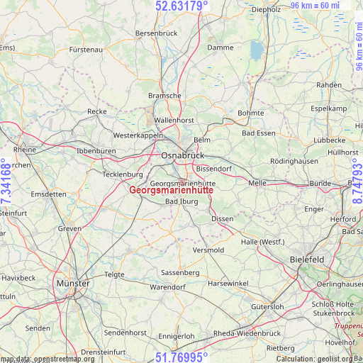
Georgsmarienhütte GPS coordinates[2]
52° 12' 10.656" North, 8° 2' 41.28" East
| Map corner | latitude | longitude |
|---|---|---|
| Upper-left | 52.63179°, | 7.34168° |
| Center: | 52.20296°, | 8.0448° |
| Lower-right: | 51.76995°, | 8.74793° |
| Map W x H: | 95.8×95.8 km | = 59.5×59.5mi |
| max Lat: | 55.01917° ⇑25.9% North |
| Georgsmarienhütte: | 52.20296° |
| min Lat: | ⇓74.1% South 47.40724° |
| min Long | Georgsmarienhü | max Long |
| 5.92978° | 8.0448° | 14.98853° |
| W 23.6%⇐ | ⇒76.4% E |
Elevation
Elevation of Georgsmarienhütte is 117 m = 384 ft, and this is 132.1 m = 433 ft below average elevation for this country.
| Max E: |
1256 m = 4121 ft | 65.6% |
| Avg. | 249.1 m = 817 ft | |
| Georgsmarienhütte | 117 m = 384 ft | |
Min E: |
-5 m = -16 ft | 34.4% |
See also: Germany elevation on elevation.city.
Geographical zone
Georgsmarienhütte is located in North temperate zone (between Tropic of Cancer and the Arctic Circle). Distance of this North polar circle is 1596.7 km =992.1 mi to North.| Distance of | km | miles | from Georgsmarienhütte |
|---|---|---|---|
| North Pole | 4202.6 | 2611.4 | to North |
| Arctic Circle | 1596.7 | 992.1 | to North |
| Tropic Cancer | 3198.5 | 1987.5 | to South |
| Equator | 5804.4 | 3606.7 | to South |


Nearby cities:
15 places around Georgsmarienhütte: (largest is in red/bold)
• Bad Iburg
5.3 km =3.3 mi,  181°
181°
• Bad Laer
11.7 km =7.3 mi,  167°
167°
• Bad Rothenfelde
12.7 km =7.9 mi,  139°
139°
• Belm
12.4 km =7.7 mi,  29°
29°
• Bissendorf
9 km =5.6 mi,  67°
67°
• Dissen
14.3 km =8.9 mi,  132°
132°
• Glandorf
13.5 km =8.4 mi,  193°
193°
• Hagen
4.5 km =2.8 mi,  260°
260°
• Hasbergen
6.9 km =4.3 mi,  304°
304°
• Hilter
10.2 km =6.3 mi, 136°
• Lengerich
12.7 km =7.9 mi, 261°
• Lienen
7.2 km =4.5 mi,  215°
215°
• Lotte
12.5 km =7.8 mi,  315°
315°
• Osnabrück
7.8 km =4.8 mi,  2°
2°
• Tecklenburg
15.9 km =9.9 mi,  276°
276°
Sources, notices
• [Note1] Compared only with cities in Germany existing in our database
• [Src1] Map data: © OpenStreetMap contributors (CC-BY-SA)
• [Src2] Other city data from geonames.org with taken over terms of usage.
• [Src3] Geographical zone / Annual Mean Temperature by Robert A. Rohde @ Wikipedia
