Lengerich geodata
Lengerich (North Rhine-Westphalia) is a populated place; located in Germany in Europe/Berlin (GMT+2) time zone. With population of 22,697 people, there are 659 cities with bigger population in this country. Compared to other cities in Germany, 73.9% of cities are located further ↓South; 79.8% of cities are located further →East and 71.5% of cities have higher elevation than Lengerich. Note1
Administrative division(s):
- Level 1: North Rhine-Westphalia
- Level 2: Regierungsbezirk Münster
- Level 3: Kreis Steinfurt
- Level 4: Lengerich


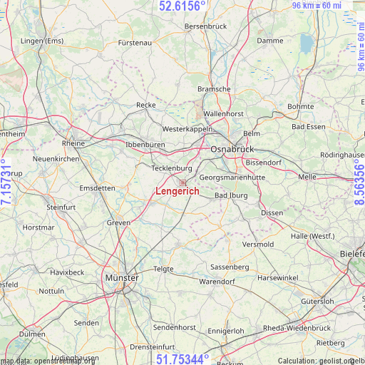
Lengerich GPS coordinates[2]
52° 11' 11.796" North, 7° 51' 37.548" East
| Map corner | latitude | longitude |
|---|---|---|
| Upper-left | 52.6156°, | 7.15731° |
| Center: | 52.18661°, | 7.86043° |
| Lower-right: | 51.75344°, | 8.56356° |
| Map W x H: | 95.9×95.9 km | = 59.6×59.6mi |
| max Lat: | 55.01917° ⇑26.1% North |
| Lengerich: | 52.18661° |
| min Lat: | ⇓73.9% South 47.40724° |
| min Long | Lengerich | max Long |
| 5.92978° | 7.86043° | 14.98853° |
| W 20.2%⇐ | ⇒79.8% E |
Elevation
Elevation of Lengerich is 81 m = 266 ft, and this is 168.1 m = 552 ft below average elevation for this country.
| Max E: |
1256 m = 4121 ft | 71.5% |
| Avg. | 249.1 m = 817 ft | |
| Lengerich | 81 m = 266 ft | |
Min E: |
-5 m = -16 ft | 28.5% |
See also: Germany elevation on elevation.city.
Geographical zone
Lengerich is located in North temperate zone (between Tropic of Cancer and the Arctic Circle). Distance of this North polar circle is 1598.6 km =993.3 mi to North.| Distance of | km | miles | from Lengerich |
|---|---|---|---|
| North Pole | 4204.5 | 2612.6 | to North |
| Arctic Circle | 1598.6 | 993.3 | to North |
| Tropic Cancer | 3196.7 | 1986.3 | to South |
| Equator | 5802.6 | 3605.6 | to South |


Nearby cities:
15 places around Lengerich: (largest is in red/bold)
• Bad Iburg
12.9 km =8 mi,  105°
105°
• Birgte
16 km =9.9 mi,  295°
295°
• Georgsmarienhütte
12.7 km =7.9 mi,  81°
81°
• Glandorf
14.8 km =9.2 mi,  140°
140°
• Hagen
8.2 km =5.1 mi, 82°
• Hasbergen
8.9 km =5.5 mi,  50°
50°
• Ibbenbüren
14.3 km =8.9 mi,  316°
316°
• Ladbergen
9.6 km =6 mi,  231°
231°
• Lienen
9.3 km =5.8 mi,  115°
115°
• Lotte
11.4 km =7.1 mi,  19°
19°
• Mettingen
15.4 km =9.6 mi,  340°
340°
• Osnabrück
16.1 km =10 mi, 53°
• Saerbeck
15.5 km =9.6 mi,  264°
264°
• Tecklenburg
4.9 km =3 mi, 318°
• Westerkappeln
14.5 km =9 mi,  6°
6°
Sources, notices
• [Note1] Compared only with cities in Germany existing in our database
• [Src1] Map data: © OpenStreetMap contributors (CC-BY-SA)
• [Src2] Other city data from geonames.org with taken over terms of usage.
• [Src3] Geographical zone / Annual Mean Temperature by Robert A. Rohde @ Wikipedia
