Bockhorn geodata
Bockhorn (Bavaria) is a seat of a fourth-order administrative division; located in Germany in Europe/Berlin (GMT+2) time zone. With population of 3,425 people, there are 3671 cities with bigger population in this country. Compared to other cities in Germany, 91.1% of cities are located further ↑North; 81.6% of cities are located further ←West and 83.9% of cities have lower elevation than Bockhorn. Note1
Administrative division(s):
- Level 1: Bavaria
- Level 2: Upper Bavaria
- Level 3: Landkreis Erding
- Level 4: Bockhorn


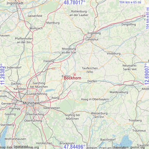
Bockhorn GPS coordinates[2]
48° 18' 52.956" North, 11° 59' 12.984" East
| Map corner | latitude | longitude |
|---|---|---|
| Upper-left | 48.78017°, | 11.28382° |
| Center: | 48.31471°, | 11.98694° |
| Lower-right: | 47.84496°, | 12.69007° |
| Map W x H: | 104×104 km | = 64.6×64.6mi |
| max Lat: | 55.01917° ⇑91.1% North |
| Bockhorn: | 48.31471° |
| min Lat: | ⇓8.9% South 47.40724° |
| min Long | Bockhorn | max Long |
| 5.92978° | 11.98694° | 14.98853° |
| W 81.6%⇐ | ⇒18.4% E |
Elevation
Elevation of Bockhorn is 461 m = 1512 ft, and this is 211.9 m = 695 ft above average elevation for this country.
| Max E: |
1256 m = 4121 ft | 16.1% |
| Bockhorn | 461 m 1512 ft | |
| Avg. | 249.1 m = 817 ft | |
Min E: |
-5 m = -16 ft | 83.9% |
See also: Germany elevation on elevation.city.
Geographical zone
Bockhorn is located in North temperate zone (between Tropic of Cancer and the Arctic Circle). Distance of this North polar circle is 2029.1 km =1260.8 mi to North.| Distance of | km | miles | from Bockhorn |
|---|---|---|---|
| North Pole | 4635 | 2880.1 | to North |
| Arctic Circle | 2029.1 | 1260.8 | to North |
| Tropic Cancer | 2766.2 | 1718.8 | to South |
| Equator | 5372.1 | 3338.1 | to South |


Nearby cities:
15 places around Bockhorn: (largest is in red/bold)
• Berglern
8.8 km =5.5 mi,  331°
331°
• Buch am Buchrain
11.1 km =6.9 mi,  176°
176°
• Eitting
8.7 km =5.4 mi,  305°
305°
• Erding
6 km =3.7 mi,  260°
260°
• Fraunberg
5.9 km =3.7 mi,  9°
9°
• Inning am Holz
7.4 km =4.6 mi,  61°
61°
• Kirchberg
10.6 km =6.6 mi,  26°
26°
• Lengdorf
7.9 km =4.9 mi,  143°
143°
• Moosinning
11.3 km =7 mi,  248°
248°
• Oberding
10.1 km =6.3 mi,  271°
271°
• Stammham
8.9 km =5.5 mi, 256°
• Steinkirchen
10.4 km =6.5 mi,  43°
43°
• Walpertskirchen
6.3 km =3.9 mi,  187°
187°
• Wartenberg
10.1 km =6.3 mi,  0°
0°
• Wörth
9.9 km =6.2 mi,  219°
219°
Sources, notices
• [Note1] Compared only with cities in Germany existing in our database
• [Src1] Map data: © OpenStreetMap contributors (CC-BY-SA)
• [Src2] Other city data from geonames.org with taken over terms of usage.
• [Src3] Geographical zone / Annual Mean Temperature by Robert A. Rohde @ Wikipedia
