Plettenberg geodata
Plettenberg (North Rhine-Westphalia) is a populated place; located in Germany in Europe/Berlin (GMT+2) time zone. With population of 28,206 people, there are 499 cities with bigger population in this country. Compared to other cities in Germany, 61.7% of cities are located further ↓South; 79.5% of cities are located further →East and 50.6% of cities have lower elevation than Plettenberg. Note1
Administrative division(s):
- Level 1: North Rhine-Westphalia
- Level 2: Regierungsbezirk Arnsberg
- Level 3: Märkischer Kreis
- Level 4: Plettenberg


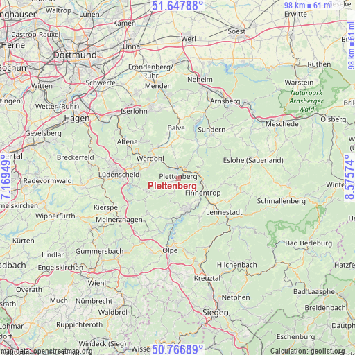
Plettenberg GPS coordinates[2]
51° 12' 34.164" North, 7° 52' 21.396" East
| Map corner | latitude | longitude |
|---|---|---|
| Upper-left | 51.64788°, | 7.16949° |
| Center: | 51.20949°, | 7.87261° |
| Lower-right: | 50.76689°, | 8.57574° |
| Map W x H: | 98×98 km | = 60.9×60.9mi |
| max Lat: | 55.01917° ⇑38.3% North |
| Plettenberg: | 51.20949° |
| min Lat: | ⇓61.7% South 47.40724° |
| min Long | Plettenberg | max Long |
| 5.92978° | 7.87261° | 14.98853° |
| W 20.5%⇐ | ⇒79.5% E |
Elevation
Elevation of Plettenberg is 230 m = 755 ft, and this is 19.1 m = 63 ft below average elevation for this country.
| Max E: |
1256 m = 4121 ft | 49.4% |
| Avg. | 249.1 m = 817 ft | |
| Plettenberg | 230 m = 755 ft | |
Min E: |
-5 m = -16 ft | 50.6% |
See also: Germany elevation on elevation.city.
Geographical zone
Plettenberg is located in North temperate zone (between Tropic of Cancer and the Arctic Circle). Distance of this North polar circle is 1707.2 km =1060.8 mi to North.| Distance of | km | miles | from Plettenberg |
|---|---|---|---|
| North Pole | 4313.1 | 2680 | to North |
| Arctic Circle | 1707.2 | 1060.8 | to North |
| Tropic Cancer | 3088 | 1918.8 | to South |
| Equator | 5694 | 3538.1 | to South |


Nearby cities:
15 places around Plettenberg: (largest is in red/bold)
• Altena
16.8 km =10.4 mi,  304°
304°
• Attendorn
9.5 km =5.9 mi,  166°
166°
• Balve
13.6 km =8.5 mi,  357°
357°
• Bamenohl
9.2 km =5.7 mi,  122°
122°
• Finnentrop
8.4 km =5.2 mi, 123°
• Hemer
21 km =13 mi,  340°
340°
• Herscheid
9.6 km =6 mi,  249°
249°
• Kirchhundem
20.4 km =12.7 mi,  132°
132°
• Lennestadt
17 km =10.6 mi, 127°
• Lüdenscheid
17.1 km =10.6 mi,  273°
273°
• Meinerzhagen
19.3 km =12 mi,  234°
234°
• Neuenrade
10.3 km =6.4 mi,  322°
322°
• Olpe
20.1 km =12.5 mi,  184°
184°
• Sundern
16 km =9.9 mi,  34°
34°
• Werdohl
9.3 km =5.8 mi,  307°
307°
Sources, notices
• [Note1] Compared only with cities in Germany existing in our database
• [Src1] Map data: © OpenStreetMap contributors (CC-BY-SA)
• [Src2] Other city data from geonames.org with taken over terms of usage.
• [Src3] Geographical zone / Annual Mean Temperature by Robert A. Rohde @ Wikipedia
