Finnentrop geodata
Finnentrop (North Rhine-Westphalia) is a seat of a fourth-order administrative division; located in Germany in Europe/Berlin (GMT+2) time zone. With population of 18,427 people, there are 854 cities with bigger population in this country. Compared to other cities in Germany, 61.1% of cities are located further ↓South; 77.6% of cities are located further →East and 53.9% of cities have lower elevation than Finnentrop. Note1
Administrative division(s):
- Level 1: North Rhine-Westphalia
- Level 2: Regierungsbezirk Arnsberg
- Level 3: Kreis Olpe
- Level 4: Finnentrop


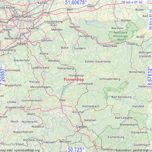
Finnentrop GPS coordinates[2]
51° 10' 4.8" North, 7° 58' 22.8" East
| Map corner | latitude | longitude |
|---|---|---|
| Upper-left | 51.60678°, | 7.26987° |
| Center: | 51.168°, | 7.973° |
| Lower-right: | 50.725°, | 8.67612° |
| Map W x H: | 98×98 km | = 60.9×60.9mi |
| max Lat: | 55.01917° ⇑38.9% North |
| Finnentrop: | 51.168° |
| min Lat: | ⇓61.1% South 47.40724° |
| min Long | Finnentrop | max Long |
| 5.92978° | 7.973° | 14.98853° |
| W 22.4%⇐ | ⇒77.6% E |
Elevation
Elevation of Finnentrop is 251 m = 823 ft, and this is 1.9 m = 6 ft above average elevation for this country.
| Max E: |
1256 m = 4121 ft | 46.1% |
| Finnentrop | 251 m 823 ft | |
| Avg. | 249.1 m = 817 ft | |
Min E: |
-5 m = -16 ft | 53.9% |
See also: Germany elevation on elevation.city.
Geographical zone
Finnentrop is located in North temperate zone (between Tropic of Cancer and the Arctic Circle). Distance of this North polar circle is 1711.8 km =1063.7 mi to North.| Distance of | km | miles | from Finnentrop |
|---|---|---|---|
| North Pole | 4317.7 | 2682.9 | to North |
| Arctic Circle | 1711.8 | 1063.7 | to North |
| Tropic Cancer | 3083.4 | 1915.9 | to South |
| Equator | 5689.3 | 3535.2 | to South |


Nearby cities:
15 places around Finnentrop: (largest is in red/bold)
• Attendorn
6.7 km =4.2 mi,  226°
226°
• Balve
19.7 km =12.2 mi,  337°
337°
• Bamenohl
0.8 km =0.5 mi,  111°
111°
• Drolshagen
21.3 km =13.2 mi,  220°
220°
• Eslohe
16.7 km =10.4 mi,  55°
55°
• Herscheid
16 km =9.9 mi,  274°
274°
• Hilchenbach
21.3 km =13.2 mi,  153°
153°
• Kirchhundem
12.2 km =7.6 mi,  138°
138°
• Lennestadt
8.7 km =5.4 mi,  130°
130°
• Neuenrade
18.4 km =11.4 mi,  313°
313°
• Olpe
17.6 km =10.9 mi,  208°
208°
• Plettenberg
8.4 km =5.2 mi,  303°
303°
• Schmallenberg
21.8 km =13.5 mi,  93°
93°
• Sundern
17.9 km =11.1 mi,  6°
6°
• Werdohl
17.7 km =11 mi, 305°
Sources, notices
• [Note1] Compared only with cities in Germany existing in our database
• [Src1] Map data: © OpenStreetMap contributors (CC-BY-SA)
• [Src2] Other city data from geonames.org with taken over terms of usage.
• [Src3] Geographical zone / Annual Mean Temperature by Robert A. Rohde @ Wikipedia
