Bamenohl geodata
Bamenohl (North Rhine-Westphalia) is a populated place; located in Germany in Europe/Berlin (GMT+2) time zone. With population of 2,896 people, there are 4100 cities with bigger population in this country. Compared to other cities in Germany, 61% of cities are located further ↓South; 77.3% of cities are located further →East and 52.2% of cities have lower elevation than Bamenohl. Note1
Administrative division(s):
- Level 1: North Rhine-Westphalia
- Level 2: Regierungsbezirk Arnsberg
- Level 3: Kreis Olpe
- Level 4: Finnentrop


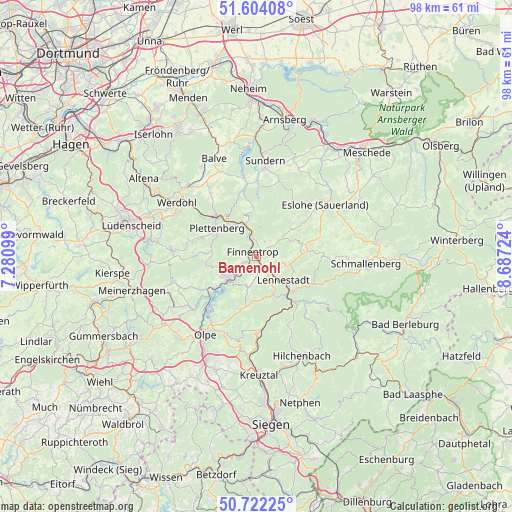
Bamenohl GPS coordinates[2]
51° 9' 54.972" North, 7° 59' 2.832" East
| Map corner | latitude | longitude |
|---|---|---|
| Upper-left | 51.60408°, | 7.28099° |
| Center: | 51.16527°, | 7.98412° |
| Lower-right: | 50.72225°, | 8.68724° |
| Map W x H: | 98.1×98 km | = 61×60.9mi |
| max Lat: | 55.01917° ⇑39% North |
| Bamenohl: | 51.16527° |
| min Lat: | ⇓61% South 47.40724° |
| min Long | Bamenohl | max Long |
| 5.92978° | 7.98412° | 14.98853° |
| W 22.7%⇐ | ⇒77.3% E |
Elevation
Elevation of Bamenohl is 241 m = 791 ft, and this is 8.1 m = 27 ft below average elevation for this country.
| Max E: |
1256 m = 4121 ft | 47.8% |
| Avg. | 249.1 m = 817 ft | |
| Bamenohl | 241 m = 791 ft | |
Min E: |
-5 m = -16 ft | 52.2% |
See also: Germany elevation on elevation.city.
Geographical zone
Bamenohl is located in North temperate zone (between Tropic of Cancer and the Arctic Circle). Distance of this North polar circle is 1712.1 km =1063.8 mi to North.| Distance of | km | miles | from Bamenohl |
|---|---|---|---|
| North Pole | 4318 | 2683.1 | to North |
| Arctic Circle | 1712.1 | 1063.8 | to North |
| Tropic Cancer | 3083.1 | 1915.7 | to South |
| Equator | 5689 | 3535 | to South |


Nearby cities:
15 places around Bamenohl: (largest is in red/bold)
• Attendorn
7.1 km =4.4 mi,  232°
232°
• Balve
20.3 km =12.6 mi,  335°
335°
• Drolshagen
21.6 km =13.4 mi,  223°
223°
• Eslohe
16.2 km =10.1 mi,  52°
52°
• Finnentrop
0.8 km =0.5 mi,  291°
291°
• Herscheid
16.8 km =10.4 mi,  275°
275°
• Hilchenbach
20.7 km =12.9 mi,  154°
154°
• Kirchhundem
11.5 km =7.1 mi,  140°
140°
• Lennestadt
7.9 km =4.9 mi,  132°
132°
• Neuenrade
19.2 km =11.9 mi,  312°
312°
• Olpe
17.8 km =11.1 mi,  211°
211°
• Plettenberg
9.2 km =5.7 mi,  302°
302°
• Schmallenberg
21 km =13 mi,  93°
93°
• Sundern
18.2 km =11.3 mi,  4°
4°
• Werdohl
18.5 km =11.5 mi, 304°
Sources, notices
• [Note1] Compared only with cities in Germany existing in our database
• [Src1] Map data: © OpenStreetMap contributors (CC-BY-SA)
• [Src2] Other city data from geonames.org with taken over terms of usage.
• [Src3] Geographical zone / Annual Mean Temperature by Robert A. Rohde @ Wikipedia
