Altomünster geodata
Altomünster (Bavaria) is a populated place; located in Germany in Europe/Berlin (GMT+2) time zone. With population of 7,275 people, there are 2124 cities with bigger population in this country. Compared to other cities in Germany, 90.4% of cities are located further ↑North; 70.8% of cities are located further ←West and 89.7% of cities have lower elevation than Altomünster. Note1
Administrative division(s):
- Level 1: Bavaria
- Level 2: Upper Bavaria
- Level 3: Landkreis Dachau
- Level 4: Altomünster, Markt


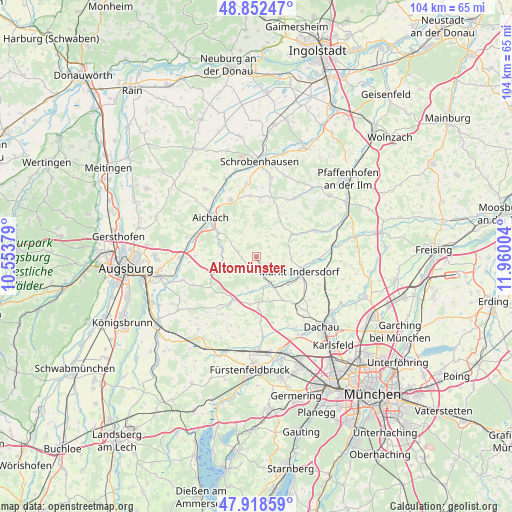
Altomünster GPS coordinates[2]
48° 23' 15.612" North, 11° 15' 24.876" East
| Map corner | latitude | longitude |
|---|---|---|
| Upper-left | 48.85247°, | 10.55379° |
| Center: | 48.38767°, | 11.25691° |
| Lower-right: | 47.91859°, | 11.96004° |
| Map W x H: | 103.8×103.8 km | = 64.5×64.5mi |
| max Lat: | 55.01917° ⇑90.4% North |
| Altomünster: | 48.38767° |
| min Lat: | ⇓9.6% South 47.40724° |
| min Long | Altomünster | max Long |
| 5.92978° | 11.25691° | 14.98853° |
| W 70.8%⇐ | ⇒29.2% E |
Elevation
Elevation of Altomünster is 510 m = 1673 ft, and this is 260.9 m = 856 ft above average elevation for this country.
| Max E: |
1256 m = 4121 ft | 10.3% |
| Altomünster | 510 m 1673 ft | |
| Avg. | 249.1 m = 817 ft | |
Min E: |
-5 m = -16 ft | 89.7% |
See also: Germany elevation on elevation.city.
Geographical zone
Altomünster is located in North temperate zone (between Tropic of Cancer and the Arctic Circle). Distance of this North polar circle is 2021 km =1255.8 mi to North.| Distance of | km | miles | from Altomünster |
|---|---|---|---|
| North Pole | 4626.9 | 2875 | to North |
| Arctic Circle | 2021 | 1255.8 | to North |
| Tropic Cancer | 2774.3 | 1723.9 | to South |
| Equator | 5380.2 | 3343.1 | to South |


Nearby cities:
15 places around Altomünster: (largest is in red/bold)
• Adelzhausen
9.4 km =5.8 mi,  248°
248°
• Aichach
11.9 km =7.4 mi,  310°
310°
• Erdweg
7.1 km =4.4 mi,  151°
151°
• Hilgertshausen-Tandern
8.6 km =5.3 mi,  57°
57°
• Kühbach
12.6 km =7.8 mi,  335°
335°
• Markt Indersdorf
9.4 km =5.8 mi,  108°
108°
• Odelzhausen
9.8 km =6.1 mi,  206°
206°
• Pfaffenhofen
3.8 km =2.4 mi,  279°
279°
• Ried
9.9 km =6.2 mi,  1°
1°
• Schiltberg
8.4 km =5.2 mi,  355°
355°
• Schwabhausen
7.6 km =4.7 mi,  78°
78°
• Schwabhausen
11.9 km =7.4 mi,  142°
142°
• Sielenbach
6.8 km =4.2 mi, 281°
• Sulzemoos
10.8 km =6.7 mi,  177°
177°
• Weichs
11.8 km =7.3 mi,  92°
92°
Sources, notices
• [Note1] Compared only with cities in Germany existing in our database
• [Src1] Map data: © OpenStreetMap contributors (CC-BY-SA)
• [Src2] Other city data from geonames.org with taken over terms of usage.
• [Src3] Geographical zone / Annual Mean Temperature by Robert A. Rohde @ Wikipedia
