Strehla geodata
Strehla (Saxony) is a populated place; located in Germany in Europe/Berlin (GMT+2) time zone. With population of 4,231 people, there are 3165 cities with bigger population in this country. Compared to other cities in Germany, 64.1% of cities are located further ↓South; 93.8% of cities are located further ←West and 65.4% of cities have higher elevation than Strehla. Note1


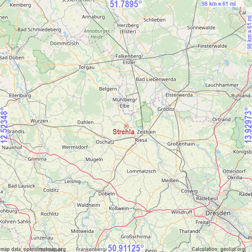
Strehla GPS coordinates[2]
51° 21' 8.928" North, 13° 13' 35.76" East
| Map corner | latitude | longitude |
|---|---|---|
| Upper-left | 51.7895°, | 12.52348° |
| Center: | 51.35248°, | 13.2266° |
| Lower-right: | 50.91125°, | 13.92973° |
| Map W x H: | 97.7×97.6 km | = 60.7×60.6mi |
| max Lat: | 55.01917° ⇑35.9% North |
| Strehla: | 51.35248° |
| min Lat: | ⇓64.1% South 47.40724° |
| min Long | Strehla | max Long |
| 5.92978° | 13.2266° | 14.98853° |
| W 93.8%⇐ | ⇒6.2% E |
Elevation
Elevation of Strehla is 118 m = 387 ft, and this is 131.1 m = 430 ft below average elevation for this country.
| Max E: |
1256 m = 4121 ft | 65.4% |
| Avg. | 249.1 m = 817 ft | |
| Strehla | 118 m = 387 ft | |
Min E: |
-5 m = -16 ft | 34.6% |
See also: Germany elevation on elevation.city.
Geographical zone
Strehla is located in North temperate zone (between Tropic of Cancer and the Arctic Circle). Distance of this North polar circle is 1691.3 km =1050.9 mi to North.| Distance of | km | miles | from Strehla |
|---|---|---|---|
| North Pole | 4297.2 | 2670.2 | to North |
| Arctic Circle | 1691.3 | 1050.9 | to North |
| Tropic Cancer | 3103.9 | 1928.7 | to South |
| Equator | 5709.9 | 3548 | to South |


Nearby cities:
15 places around Strehla: (largest is in red/bold)
• Belgern
16.1 km =10 mi,  333°
333°
• Cavertitz
7.3 km =4.5 mi,  297°
297°
• Dahlen
15.9 km =9.9 mi,  275°
275°
• Glaubitz
11 km =6.8 mi,  106°
106°
• Mühlberg
9.1 km =5.7 mi,  357°
357°
• Naundorf
13.4 km =8.3 mi,  217°
217°
• Nauwalde
14.7 km =9.1 mi,  60°
60°
• Nünchritz
12.5 km =7.8 mi,  117°
117°
• Oschatz
10 km =6.2 mi,  234°
234°
• Ostrau
17.5 km =10.9 mi,  193°
193°
• Riesa
6.7 km =4.2 mi,  137°
137°
• Stauchitz
12.1 km =7.5 mi,  184°
184°
• Weißig
16.4 km =10.2 mi, 114°
• Wülknitz
12.1 km =7.5 mi,  82°
82°
• Zeithain
8 km =5 mi, 105°
Sources, notices
• [Note1] Compared only with cities in Germany existing in our database
• [Src1] Map data: © OpenStreetMap contributors (CC-BY-SA)
• [Src2] Other city data from geonames.org with taken over terms of usage.
• [Src3] Geographical zone / Annual Mean Temperature by Robert A. Rohde @ Wikipedia
