Stolzenau geodata
Stolzenau (Lower Saxony) is a seat of a fourth-order administrative division; located in Germany in Europe/Berlin (GMT+2) time zone. With population of 7,473 people, there are 2077 cities with bigger population in this country. Compared to other cities in Germany, 77.6% of cities are located further ↓South; 64.5% of cities are located further →East and 87% of cities have higher elevation than Stolzenau. Note1
Administrative division(s):
- Level 1: Lower Saxony
- Level 3: Landkreis Nienburg/Weser
- Level 4: Stolzenau


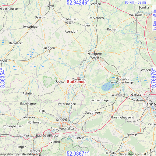
Stolzenau GPS coordinates[2]
52° 31' 0.012" North, 9° 4' 0.012" East
| Map corner | latitude | longitude |
|---|---|---|
| Upper-left | 52.94246°, | 8.36354° |
| Center: | 52.51667°, | 9.06667° |
| Lower-right: | 52.08671°, | 9.76979° |
| Map W x H: | 95.2×95.1 km | = 59.2×59.1mi |
| max Lat: | 55.01917° ⇑22.4% North |
| Stolzenau: | 52.51667° |
| min Lat: | ⇓77.6% South 47.40724° |
| min Long | Stolzenau | max Long |
| 5.92978° | 9.06667° | 14.98853° |
| W 35.5%⇐ | ⇒64.5% E |
Elevation
Elevation of Stolzenau is 30 m = 98 ft, and this is 219.1 m = 719 ft below average elevation for this country.
| Max E: |
1256 m = 4121 ft | 87% |
| Avg. | 249.1 m = 817 ft | |
| Stolzenau | 30 m = 98 ft | |
Min E: |
-5 m = -16 ft | 13% |
See also: Germany elevation on elevation.city.
Geographical zone
Stolzenau is located in North temperate zone (between Tropic of Cancer and the Arctic Circle). Distance of this North polar circle is 1561.9 km =970.5 mi to North.| Distance of | km | miles | from Stolzenau |
|---|---|---|---|
| North Pole | 4167.8 | 2589.8 | to North |
| Arctic Circle | 1561.9 | 970.5 | to North |
| Tropic Cancer | 3233.4 | 2009.1 | to South |
| Equator | 5839.3 | 3628.4 | to South |


Nearby cities:
15 places around Stolzenau: (largest is in red/bold)
• Binnen
12 km =7.5 mi,  22°
22°
• Estorf
9.5 km =5.9 mi,  32°
32°
• Halle
14.4 km =8.9 mi,  223°
223°
• Husum
13.6 km =8.5 mi,  65°
65°
• Landesbergen
5.9 km =3.7 mi,  42°
42°
• Leese
3.9 km =2.4 mi,  118°
118°
• Liebenau
9.9 km =6.2 mi,  12°
12°
• Pennigsehl
14.2 km =8.8 mi,  348°
348°
• Raddestorf
10 km =6.2 mi, 222°
• Rehburg-Loccum
10.4 km =6.5 mi, 120°
• Steyerberg
6.6 km =4.1 mi,  334°
334°
• Uchte
10.8 km =6.7 mi,  259°
259°
• Warmsen
16.1 km =10 mi,  245°
245°
• Wiedensahl
15.2 km =9.4 mi,  166°
166°
• Wölpinghausen
15.8 km =9.8 mi,  134°
134°
Sources, notices
• [Note1] Compared only with cities in Germany existing in our database
• [Src1] Map data: © OpenStreetMap contributors (CC-BY-SA)
• [Src2] Other city data from geonames.org with taken over terms of usage.
• [Src3] Geographical zone / Annual Mean Temperature by Robert A. Rohde @ Wikipedia
