Rehburg-Loccum geodata
Rehburg-Loccum (Lower Saxony) is a populated place; located in Germany in Europe/Berlin (GMT+2) time zone. With population of 10,894 people, there are 1513 cities with bigger population in this country. Compared to other cities in Germany, 77.1% of cities are located further ↓South; 62.4% of cities are located further →East and 83.7% of cities have higher elevation than Rehburg-Loccum. Note1
Administrative division(s):
- Level 1: Lower Saxony
- Level 3: Landkreis Nienburg/Weser
- Level 4: Rehburg-Loccum


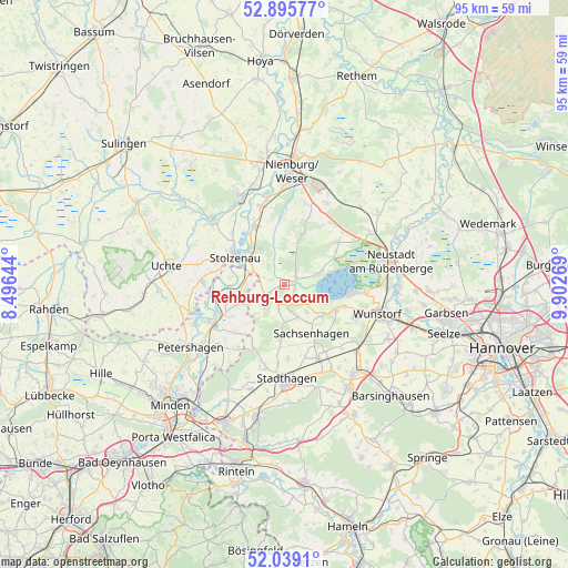
Rehburg-Loccum GPS coordinates[2]
52° 28' 10.272" North, 9° 11' 58.452" East
| Map corner | latitude | longitude |
|---|---|---|
| Upper-left | 52.89577°, | 8.49644° |
| Center: | 52.46952°, | 9.19957° |
| Lower-right: | 52.0391°, | 9.90269° |
| Map W x H: | 95.3×95.3 km | = 59.2×59.2mi |
| max Lat: | 55.01917° ⇑22.9% North |
| Rehburg-Loccum: | 52.46952° |
| min Lat: | ⇓77.1% South 47.40724° |
| min Long | Rehburg-Loccum | max Long |
| 5.92978° | 9.19957° | 14.98853° |
| W 37.6%⇐ | ⇒62.4% E |
Elevation
Elevation of Rehburg-Loccum is 38 m = 125 ft, and this is 211.1 m = 693 ft below average elevation for this country.
| Max E: |
1256 m = 4121 ft | 83.7% |
| Avg. | 249.1 m = 817 ft | |
| Rehburg-Loccum | 38 m = 125 ft | |
Min E: |
-5 m = -16 ft | 16.3% |
See also: Germany elevation on elevation.city.
Geographical zone
Rehburg-Loccum is located in North temperate zone (between Tropic of Cancer and the Arctic Circle). Distance of this North polar circle is 1567.1 km =973.8 mi to North.| Distance of | km | miles | from Rehburg-Loccum |
|---|---|---|---|
| North Pole | 4173 | 2593 | to North |
| Arctic Circle | 1567.1 | 973.8 | to North |
| Tropic Cancer | 3228.1 | 2005.8 | to South |
| Equator | 5834.1 | 3625.1 | to South |


Nearby cities:
15 places around Rehburg-Loccum: (largest is in red/bold)
• Auhagen
10.1 km =6.3 mi,  141°
141°
• Hagenburg
9.4 km =5.8 mi,  115°
115°
• Husum
11.3 km =7 mi,  17°
17°
• Landesbergen
10.9 km =6.8 mi,  332°
332°
• Lauenhagen
12.7 km =7.9 mi,  177°
177°
• Leese
6.6 km =4.1 mi,  301°
301°
• Lindhorst
13.6 km =8.5 mi,  155°
155°
• Lüdersfeld
12.7 km =7.9 mi, 163°
• Niedernwöhren
13.5 km =8.4 mi,  195°
195°
• Nordsehl
13.3 km =8.3 mi, 184°
• Pollhagen
9.4 km =5.8 mi, 184°
• Sachsenhagen
9.3 km =5.8 mi,  150°
150°
• Stolzenau
10.4 km =6.5 mi, 300°
• Wiedensahl
10.9 km =6.8 mi,  209°
209°
• Wölpinghausen
6.3 km =3.9 mi, 158°
Sources, notices
• [Note1] Compared only with cities in Germany existing in our database
• [Src1] Map data: © OpenStreetMap contributors (CC-BY-SA)
• [Src2] Other city data from geonames.org with taken over terms of usage.
• [Src3] Geographical zone / Annual Mean Temperature by Robert A. Rohde @ Wikipedia
