Estorf geodata
Estorf (Lower Saxony) is a seat of a fourth-order administrative division; located in Germany in Europe/Berlin (GMT+2) time zone. With population of 1,709 people, there are 5496 cities with bigger population in this country. Compared to other cities in Germany, 78.6% of cities are located further ↓South; 63.4% of cities are located further →East and 86.3% of cities have higher elevation than Estorf. Note1


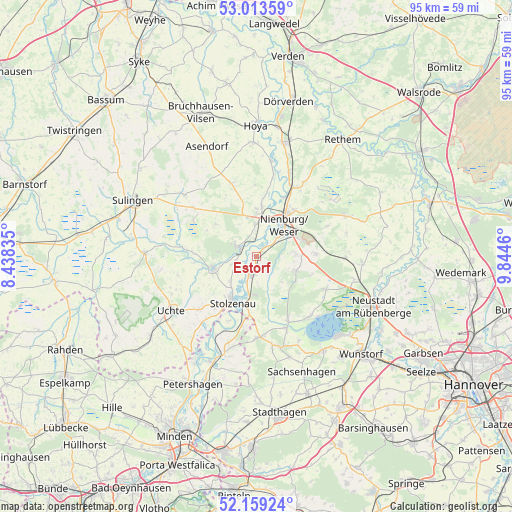
Estorf GPS coordinates[2]
52° 35' 18.6" North, 9° 8' 29.292" East
| Map corner | latitude | longitude |
|---|---|---|
| Upper-left | 53.01359°, | 8.43835° |
| Center: | 52.5885°, | 9.14147° |
| Lower-right: | 52.15924°, | 9.8446° |
| Map W x H: | 95×95 km | = 59×59mi |
| max Lat: | 55.01917° ⇑21.4% North |
| Estorf: | 52.5885° |
| min Lat: | ⇓78.6% South 47.40724° |
| min Long | Estorf | max Long |
| 5.92978° | 9.14147° | 14.98853° |
| W 36.6%⇐ | ⇒63.4% E |
Elevation
Elevation of Estorf is 32 m = 105 ft, and this is 217.1 m = 712 ft below average elevation for this country.
| Max E: |
1256 m = 4121 ft | 86.3% |
| Avg. | 249.1 m = 817 ft | |
| Estorf | 32 m = 105 ft | |
Min E: |
-5 m = -16 ft | 13.7% |
See also: Germany elevation on elevation.city.
Geographical zone
Estorf is located in North temperate zone (between Tropic of Cancer and the Arctic Circle). Distance of this North polar circle is 1553.9 km =965.5 mi to North.| Distance of | km | miles | from Estorf |
|---|---|---|---|
| North Pole | 4159.8 | 2584.8 | to North |
| Arctic Circle | 1553.9 | 965.5 | to North |
| Tropic Cancer | 3241.4 | 2014.1 | to South |
| Equator | 5847.3 | 3633.3 | to South |


Nearby cities:
15 places around Estorf: (largest is in red/bold)
• Balge
14.4 km =8.9 mi,  6°
6°
• Binnen
3.2 km =2 mi,  350°
350°
• Drakenburg
11.9 km =7.4 mi,  23°
23°
• Husum
7.7 km =4.8 mi,  108°
108°
• Landesbergen
3.8 km =2.4 mi,  197°
197°
• Leese
10 km =6.2 mi,  189°
189°
• Liebenau
3.4 km =2.1 mi,  299°
299°
• Linsburg
10.9 km =6.8 mi,  87°
87°
• Marklohe
8.9 km =5.5 mi,  0°
0°
• Nienburg
8.4 km =5.2 mi,  39°
39°
• Pennigsehl
9.8 km =6.1 mi,  307°
307°
• Rehburg-Loccum
13.8 km =8.6 mi,  163°
163°
• Steyerberg
8.2 km =5.1 mi,  255°
255°
• Stolzenau
9.5 km =5.9 mi,  212°
212°
• Stöckse
14.6 km =9.1 mi,  66°
66°
Sources, notices
• [Note1] Compared only with cities in Germany existing in our database
• [Src1] Map data: © OpenStreetMap contributors (CC-BY-SA)
• [Src2] Other city data from geonames.org with taken over terms of usage.
• [Src3] Geographical zone / Annual Mean Temperature by Robert A. Rohde @ Wikipedia
