Warmsen geodata
Warmsen (Lower Saxony) is a seat of a fourth-order administrative division; located in Germany in Europe/Berlin (GMT+2) time zone. With population of 3,552 people, there are 3573 cities with bigger population in this country. Compared to other cities in Germany, 76.9% of cities are located further ↓South; 67.3% of cities are located further →East and 80.2% of cities have higher elevation than Warmsen. Note1
Administrative division(s):
- Level 1: Lower Saxony
- Level 3: Landkreis Nienburg/Weser
- Level 4: Warmsen


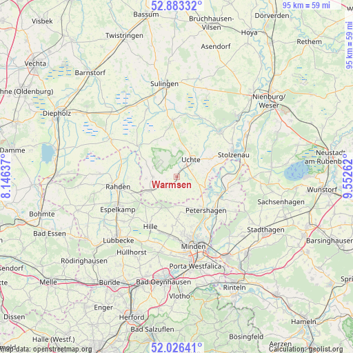
Warmsen GPS coordinates[2]
52° 27' 25.02" North, 8° 50' 58.164" East
| Map corner | latitude | longitude |
|---|---|---|
| Upper-left | 52.88332°, | 8.14637° |
| Center: | 52.45695°, | 8.84949° |
| Lower-right: | 52.02641°, | 9.55262° |
| Map W x H: | 95.3×95.3 km | = 59.2×59.2mi |
| max Lat: | 55.01917° ⇑23.1% North |
| Warmsen: | 52.45695° |
| min Lat: | ⇓76.9% South 47.40724° |
| min Long | Warmsen | max Long |
| 5.92978° | 8.84949° | 14.98853° |
| W 32.7%⇐ | ⇒67.3% E |
Elevation
Elevation of Warmsen is 46 m = 151 ft, and this is 203.1 m = 666 ft below average elevation for this country.
| Max E: |
1256 m = 4121 ft | 80.2% |
| Avg. | 249.1 m = 817 ft | |
| Warmsen | 46 m = 151 ft | |
Min E: |
-5 m = -16 ft | 19.8% |
See also: Germany elevation on elevation.city.
Geographical zone
Warmsen is located in North temperate zone (between Tropic of Cancer and the Arctic Circle). Distance of this North polar circle is 1568.5 km =974.6 mi to North.| Distance of | km | miles | from Warmsen |
|---|---|---|---|
| North Pole | 4174.4 | 2593.9 | to North |
| Arctic Circle | 1568.5 | 974.6 | to North |
| Tropic Cancer | 3226.7 | 2005 | to South |
| Equator | 5832.7 | 3624.3 | to South |


Nearby cities:
15 places around Warmsen: (largest is in red/bold)
• Bahrenborstel
12.9 km =8 mi,  347°
347°
• Barenburg
18.4 km =11.4 mi, 349°
• Espelkamp
17.6 km =10.9 mi,  241°
241°
• Halle
6.2 km =3.9 mi,  128°
128°
• Hille
15.3 km =9.5 mi,  206°
206°
• Kirchdorf
15.4 km =9.6 mi,  356°
356°
• Leese
18.7 km =11.6 mi,  75°
75°
• Minden
19.1 km =11.9 mi,  166°
166°
• Petershagen
12 km =7.5 mi,  139°
139°
• Raddestorf
8 km =5 mi,  95°
95°
• Rahden
16.3 km =10.1 mi,  260°
260°
• Steyerberg
17.3 km =10.7 mi,  43°
43°
• Stolzenau
16.1 km =10 mi,  65°
65°
• Uchte
6.2 km =3.9 mi, 40°
• Varrel
19.9 km =12.4 mi,  336°
336°
Sources, notices
• [Note1] Compared only with cities in Germany existing in our database
• [Src1] Map data: © OpenStreetMap contributors (CC-BY-SA)
• [Src2] Other city data from geonames.org with taken over terms of usage.
• [Src3] Geographical zone / Annual Mean Temperature by Robert A. Rohde @ Wikipedia
