Steyerberg geodata
Steyerberg (Lower Saxony) is a populated place; located in Germany in Europe/Berlin (GMT+2) time zone. With population of 5,368 people, there are 2675 cities with bigger population in this country. Compared to other cities in Germany, 78.4% of cities are located further ↓South; 65.1% of cities are located further →East and 87.3% of cities have higher elevation than Steyerberg. Note1
Administrative division(s):
- Level 1: Lower Saxony
- Level 3: Landkreis Nienburg/Weser
- Level 4: Steyerberg, Flecken


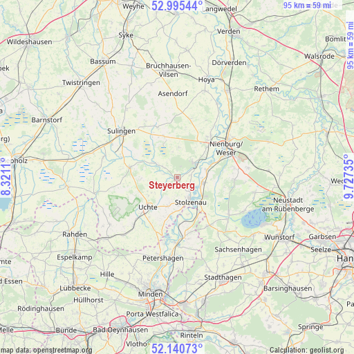
Steyerberg GPS coordinates[2]
52° 34' 12.612" North, 9° 1' 27.228" East
| Map corner | latitude | longitude |
|---|---|---|
| Upper-left | 52.99544°, | 8.3211° |
| Center: | 52.57017°, | 9.02423° |
| Lower-right: | 52.14073°, | 9.72735° |
| Map W x H: | 95×95 km | = 59×59mi |
| max Lat: | 55.01917° ⇑21.6% North |
| Steyerberg: | 52.57017° |
| min Lat: | ⇓78.4% South 47.40724° |
| min Long | Steyerberg | max Long |
| 5.92978° | 9.02423° | 14.98853° |
| W 34.9%⇐ | ⇒65.1% E |
Elevation
Elevation of Steyerberg is 29 m = 95 ft, and this is 220.1 m = 722 ft below average elevation for this country.
| Max E: |
1256 m = 4121 ft | 87.3% |
| Avg. | 249.1 m = 817 ft | |
| Steyerberg | 29 m = 95 ft | |
Min E: |
-5 m = -16 ft | 12.7% |
See also: Germany elevation on elevation.city.
Geographical zone
Steyerberg is located in North temperate zone (between Tropic of Cancer and the Arctic Circle). Distance of this North polar circle is 1555.9 km =966.8 mi to North.| Distance of | km | miles | from Steyerberg |
|---|---|---|---|
| North Pole | 4161.8 | 2586 | to North |
| Arctic Circle | 1555.9 | 966.8 | to North |
| Tropic Cancer | 3239.3 | 2012.8 | to South |
| Equator | 5845.3 | 3632.1 | to South |


Nearby cities:
15 places around Steyerberg: (largest is in red/bold)
• Bahrenborstel
14.6 km =9.1 mi,  269°
269°
• Binnen
9 km =5.6 mi,  54°
54°
• Borstel
11.7 km =7.3 mi,  341°
341°
• Estorf
8.2 km =5.1 mi,  75°
75°
• Husum
15.3 km =9.5 mi,  91°
91°
• Kirchdorf
13.1 km =8.1 mi,  282°
282°
• Landesbergen
7 km =4.3 mi,  103°
103°
• Leese
10 km =6.2 mi,  141°
141°
• Liebenau
6.2 km =3.9 mi, 52°
• Marklohe
13.5 km =8.4 mi,  36°
36°
• Pennigsehl
8 km =5 mi,  1°
1°
• Raddestorf
13.9 km =8.6 mi,  196°
196°
• Siedenburg
14.8 km =9.2 mi, 337°
• Stolzenau
6.6 km =4.1 mi,  154°
154°
• Uchte
11 km =6.8 mi,  224°
224°
Sources, notices
• [Note1] Compared only with cities in Germany existing in our database
• [Src1] Map data: © OpenStreetMap contributors (CC-BY-SA)
• [Src2] Other city data from geonames.org with taken over terms of usage.
• [Src3] Geographical zone / Annual Mean Temperature by Robert A. Rohde @ Wikipedia
