Elmlohe geodata
Elmlohe (Lower Saxony) is a seat of a fourth-order administrative division; located in Germany in Europe/Berlin (GMT+2) time zone. With population of 887 people, there are 7570 cities with bigger population in this country. Compared to other cities in Germany, 86.8% of cities are located further ↓South; 68.6% of cities are located further →East and 96.6% of cities have higher elevation than Elmlohe. Note1


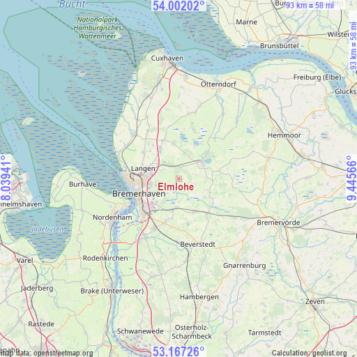
Elmlohe GPS coordinates[2]
53° 35' 12.12" North, 8° 44' 33.144" East
| Map corner | latitude | longitude |
|---|---|---|
| Upper-left | 54.00202°, | 8.03941° |
| Center: | 53.5867°, | 8.74254° |
| Lower-right: | 53.16726°, | 9.44566° |
| Map W x H: | 92.8×92.8 km | = 57.7×57.7mi |
| max Lat: | 55.01917° ⇑13.2% North |
| Elmlohe: | 53.5867° |
| min Lat: | ⇓86.8% South 47.40724° |
| min Long | Elmlohe | max Long |
| 5.92978° | 8.74254° | 14.98853° |
| W 31.4%⇐ | ⇒68.6% E |
Elevation
Elevation of Elmlohe is 5 m = 16 ft, and this is 244.1 m = 801 ft below average elevation for this country.
| Max E: |
1256 m = 4121 ft | 96.6% |
| Avg. | 249.1 m = 817 ft | |
| Elmlohe | 5 m = 16 ft | |
Min E: |
-5 m = -16 ft | 3.4% |
See also: Germany elevation on elevation.city.
Geographical zone
Elmlohe is located in North temperate zone (between Tropic of Cancer and the Arctic Circle). Distance of this North polar circle is 1442.9 km =896.6 mi to North.| Distance of | km | miles | from Elmlohe |
|---|---|---|---|
| North Pole | 4048.8 | 2515.8 | to North |
| Arctic Circle | 1442.9 | 896.6 | to North |
| Tropic Cancer | 3352.4 | 2083.1 | to South |
| Equator | 5958.3 | 3702.3 | to South |


Nearby cities:
15 places around Elmlohe: (largest is in red/bold)
• Bremerhaven
11.7 km =7.3 mi,  249°
249°
• Drangstedt
3.1 km =1.9 mi,  16°
16°
• Flögeln
9.3 km =5.8 mi,  26°
26°
• Frelsdorf
14.8 km =9.2 mi,  135°
135°
• Heerstedt
13.6 km =8.5 mi,  175°
175°
• Köhlen
10.1 km =6.3 mi,  120°
120°
• Kührstedt
4 km =2.5 mi,  104°
104°
• Langen
10 km =6.2 mi,  282°
282°
• Lintig
9.2 km =5.7 mi,  78°
78°
• Loxstedt
14.7 km =9.1 mi,  204°
204°
• Mulsum
15.5 km =9.6 mi,  305°
305°
• Ringstedt
7.6 km =4.7 mi,  112°
112°
• Schiffdorf
8.5 km =5.3 mi,  225°
225°
• Steinau
14.2 km =8.8 mi,  40°
40°
• Stinstedt
12.8 km =8 mi,  189°
189°
Sources, notices
• [Note1] Compared only with cities in Germany existing in our database
• [Src1] Map data: © OpenStreetMap contributors (CC-BY-SA)
• [Src2] Other city data from geonames.org with taken over terms of usage.
• [Src3] Geographical zone / Annual Mean Temperature by Robert A. Rohde @ Wikipedia
