Markdorf geodata
Markdorf (Baden-Württemberg) is a populated place; located in Germany in Europe/Berlin (GMT+2) time zone. With population of 12,486 people, there are 1301 cities with bigger population in this country. Compared to other cities in Germany, 98.6% of cities are located further ↑North; 59.4% of cities are located further →East and 81.2% of cities have lower elevation than Markdorf. Note1
Administrative division(s):
- Level 1: Baden-Württemberg
- Level 2: Tübingen Region
- Level 3: Bodenseekreis
- Level 4: Markdorf


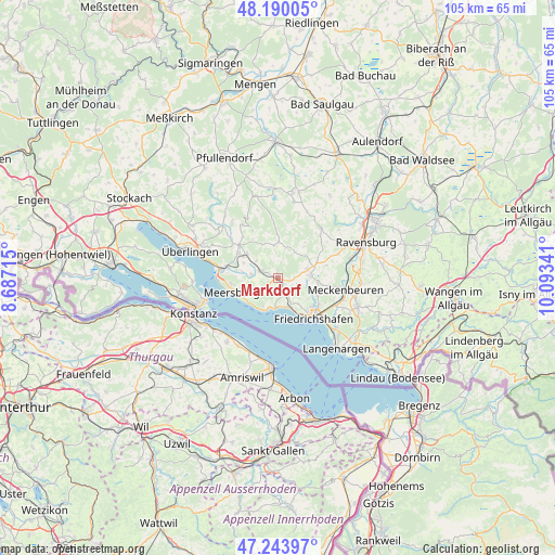
Markdorf GPS coordinates[2]
47° 43' 8.976" North, 9° 23' 25.008" East
| Map corner | latitude | longitude |
|---|---|---|
| Upper-left | 48.19005°, | 8.68715° |
| Center: | 47.71916°, | 9.39028° |
| Lower-right: | 47.24397°, | 10.09341° |
| Map W x H: | 105.2×105.2 km | = 65.4×65.4mi |
| max Lat: | 55.01917° ⇑98.6% North |
| Markdorf: | 47.71916° |
| min Lat: | ⇓1.4% South 47.40724° |
| min Long | Markdorf | max Long |
| 5.92978° | 9.39028° | 14.98853° |
| W 40.6%⇐ | ⇒59.4% E |
Elevation
Elevation of Markdorf is 441 m = 1447 ft, and this is 191.9 m = 630 ft above average elevation for this country.
| Max E: |
1256 m = 4121 ft | 18.8% |
| Markdorf | 441 m 1447 ft | |
| Avg. | 249.1 m = 817 ft | |
Min E: |
-5 m = -16 ft | 81.2% |
See also: Germany elevation on elevation.city.
Geographical zone
Markdorf is located in North temperate zone (between Tropic of Cancer and the Arctic Circle). Distance of this North polar circle is 2095.3 km =1302 mi to North.| Distance of | km | miles | from Markdorf |
|---|---|---|---|
| North Pole | 4701.2 | 2921.2 | to North |
| Arctic Circle | 2095.3 | 1302 | to North |
| Tropic Cancer | 2700 | 1677.7 | to South |
| Equator | 5305.9 | 3296.9 | to South |


Nearby cities:
15 places around Markdorf: (largest is in red/bold)
• Bermatingen
3.4 km =2.1 mi,  297°
297°
• Daisendorf
9.2 km =5.7 mi,  265°
265°
• Eriskirch
15.5 km =9.6 mi,  132°
132°
• Frickingen
13.7 km =8.5 mi,  320°
320°
• Friedrichshafen
9.4 km =5.8 mi,  137°
137°
• Hagnau
7.2 km =4.5 mi,  228°
228°
• Heiligenberg
12.7 km =7.9 mi,  332°
332°
• Horgenzell
12.5 km =7.8 mi,  39°
39°
• Immenstaad am Bodensee
6.1 km =3.8 mi,  196°
196°
• Meckenbeuren
13.4 km =8.3 mi,  99°
99°
• Meersburg
9.3 km =5.8 mi,  252°
252°
• Oberteuringen
6 km =3.7 mi,  84°
84°
• Salem
8.9 km =5.5 mi, 302°
• Stetten
7.6 km =4.7 mi,  244°
244°
• Uhldingen-Mühlhofen
10.6 km =6.6 mi,  278°
278°
Sources, notices
• [Note1] Compared only with cities in Germany existing in our database
• [Src1] Map data: © OpenStreetMap contributors (CC-BY-SA)
• [Src2] Other city data from geonames.org with taken over terms of usage.
• [Src3] Geographical zone / Annual Mean Temperature by Robert A. Rohde @ Wikipedia
