Steinwiesen geodata
Steinwiesen (Bavaria) is a populated place; located in Germany in Europe/Berlin (GMT+2) time zone. With population of 3,869 people, there are 3366 cities with bigger population in this country. Compared to other cities in Germany, 56.9% of cities are located further ↑North; 73.7% of cities are located further ←West and 70.9% of cities have lower elevation than Steinwiesen. Note1
Administrative division(s):
- Level 1: Bavaria
- Level 2: Upper Franconia
- Level 3: Landkreis Kronach
- Level 4: Steinwiesen, Markt


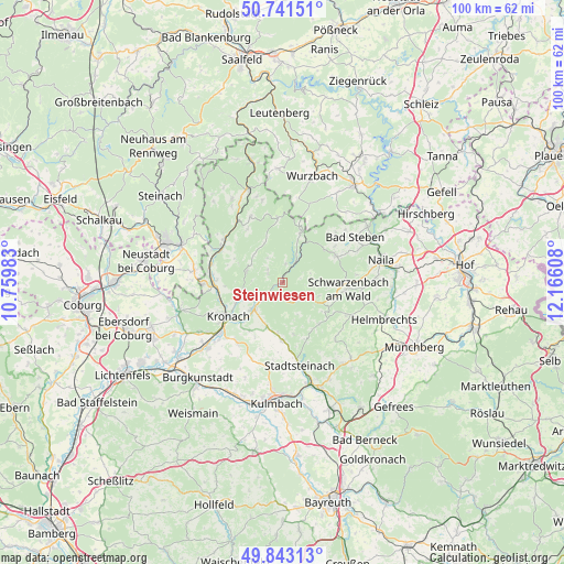
Steinwiesen GPS coordinates[2]
50° 17' 39.984" North, 11° 27' 46.62" East
| Map corner | latitude | longitude |
|---|---|---|
| Upper-left | 50.74151°, | 10.75983° |
| Center: | 50.29444°, | 11.46295° |
| Lower-right: | 49.84313°, | 12.16608° |
| Map W x H: | 99.9×99.9 km | = 62.1×62.1mi |
| max Lat: | 55.01917° ⇑56.9% North |
| Steinwiesen: | 50.29444° |
| min Lat: | ⇓43.1% South 47.40724° |
| min Long | Steinwiesen | max Long |
| 5.92978° | 11.46295° | 14.98853° |
| W 73.7%⇐ | ⇒26.3% E |
Elevation
Elevation of Steinwiesen is 365 m = 1198 ft, and this is 115.9 m = 380 ft above average elevation for this country.
| Max E: |
1256 m = 4121 ft | 29.1% |
| Steinwiesen | 365 m 1198 ft | |
| Avg. | 249.1 m = 817 ft | |
Min E: |
-5 m = -16 ft | 70.9% |
See also: Germany elevation on elevation.city.
Geographical zone
Steinwiesen is located in North temperate zone (between Tropic of Cancer and the Arctic Circle). Distance of this North polar circle is 1809 km =1124.1 mi to North.| Distance of | km | miles | from Steinwiesen |
|---|---|---|---|
| North Pole | 4414.8 | 2743.2 | to North |
| Arctic Circle | 1809 | 1124.1 | to North |
| Tropic Cancer | 2986.3 | 1855.6 | to South |
| Equator | 5592.2 | 3474.8 | to South |


Nearby cities:
15 places around Steinwiesen: (largest is in red/bold)
• Geroldsgrün
10.6 km =6.6 mi,  66°
66°
• Kronach
11.1 km =6.9 mi,  236°
236°
• Kunreuth
8.4 km =5.2 mi,  144°
144°
• Marktrodach
7.5 km =4.7 mi,  228°
228°
• Nordhalben
9.5 km =5.9 mi,  20°
20°
• Presseck
9.9 km =6.2 mi, 138°
• Pressig
12.6 km =7.8 mi,  300°
300°
• Reichenbach
6.3 km =3.9 mi,  155°
155°
• Rugendorf
10.5 km =6.5 mi,  178°
178°
• Stockheim
12.9 km =8 mi,  275°
275°
• Teuschnitz
12.9 km =8 mi,  333°
333°
• Tschirn
11.8 km =7.3 mi,  355°
355°
• Wallenfels
2.9 km =1.8 mi,  169°
169°
• Weißenbrunn
13.2 km =8.2 mi,  217°
217°
• Wilhelmsthal
6.7 km =4.2 mi,  286°
286°
Sources, notices
• [Note1] Compared only with cities in Germany existing in our database
• [Src1] Map data: © OpenStreetMap contributors (CC-BY-SA)
• [Src2] Other city data from geonames.org with taken over terms of usage.
• [Src3] Geographical zone / Annual Mean Temperature by Robert A. Rohde @ Wikipedia
