Tschirn geodata
Tschirn (Bavaria) is a seat of a fourth-order administrative division; located in Germany in Europe/Berlin (GMT+2) time zone. With population of 621 people, there are 8713 cities with bigger population in this country. Compared to other cities in Germany, 54.7% of cities are located further ↑North; 73.4% of cities are located further ←West and 96.6% of cities have lower elevation than Tschirn. Note1
Administrative division(s):
- Level 1: Bavaria
- Level 2: Upper Franconia
- Level 3: Landkreis Kronach
- Level 4: Tschirn


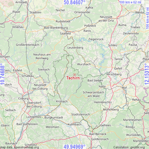
Tschirn GPS coordinates[2]
50° 24' 0" North, 11° 27' 0" East
| Map corner | latitude | longitude |
|---|---|---|
| Upper-left | 50.84607°, | 10.74688° |
| Center: | 50.4°, | 11.45° |
| Lower-right: | 49.94969°, | 12.15313° |
| Map W x H: | 99.7×99.7 km | = 62×62mi |
| max Lat: | 55.01917° ⇑54.7% North |
| Tschirn: | 50.4° |
| min Lat: | ⇓45.3% South 47.40724° |
| min Long | Tschirn | max Long |
| 5.92978° | 11.45° | 14.98853° |
| W 73.4%⇐ | ⇒26.6% E |
Elevation
Elevation of Tschirn is 646 m = 2119 ft, and this is 396.9 m = 1302 ft above average elevation for this country.
| Max E: |
1256 m = 4121 ft | 3.4% |
| Tschirn | 646 m 2119 ft | |
| Avg. | 249.1 m = 817 ft | |
Min E: |
-5 m = -16 ft | 96.6% |
See also: Germany elevation on elevation.city.
Geographical zone
Tschirn is located in North temperate zone (between Tropic of Cancer and the Arctic Circle). Distance of this North polar circle is 1797.2 km =1116.7 mi to North.| Distance of | km | miles | from Tschirn |
|---|---|---|---|
| North Pole | 4403.1 | 2736 | to North |
| Arctic Circle | 1797.2 | 1116.7 | to North |
| Tropic Cancer | 2998 | 1862.9 | to South |
| Equator | 5604 | 3482.2 | to South |


Nearby cities:
15 places around Tschirn: (largest is in red/bold)
• Bad Lobenstein
14.6 km =9.1 mi,  66°
66°
• Bad Steben
14.3 km =8.9 mi,  105°
105°
• Geroldsgrün
13 km =8.1 mi,  124°
124°
• Ludwigsstadt
10.5 km =6.5 mi,  335°
335°
• Nordhalben
5.1 km =3.2 mi, 124°
• Pressig
11.3 km =7 mi,  242°
242°
• Probstzella
15.6 km =9.7 mi, 342°
• Reichenbach
3.8 km =2.4 mi,  315°
315°
• Schlegel
11.8 km =7.3 mi,  90°
90°
• Steinwiesen
11.8 km =7.3 mi,  175°
175°
• Tettau
15.6 km =9.7 mi,  299°
299°
• Teuschnitz
4.8 km =3 mi,  267°
267°
• Wallenfels
14.7 km =9.1 mi,  174°
174°
• Wilhelmsthal
11.3 km =7 mi,  209°
209°
• Wurzbach
9.4 km =5.8 mi,  41°
41°
Sources, notices
• [Note1] Compared only with cities in Germany existing in our database
• [Src1] Map data: © OpenStreetMap contributors (CC-BY-SA)
• [Src2] Other city data from geonames.org with taken over terms of usage.
• [Src3] Geographical zone / Annual Mean Temperature by Robert A. Rohde @ Wikipedia
