Rauen geodata
Rauen (Brandenburg) is a seat of a fourth-order administrative division; located in Germany in Europe/Berlin (GMT+2) time zone. With population of 1,901 people, there are 5203 cities with bigger population in this country. Compared to other cities in Germany, 75.5% of cities are located further ↓South; 98.1% of cities are located further ←West and 73.4% of cities have higher elevation than Rauen. Note1


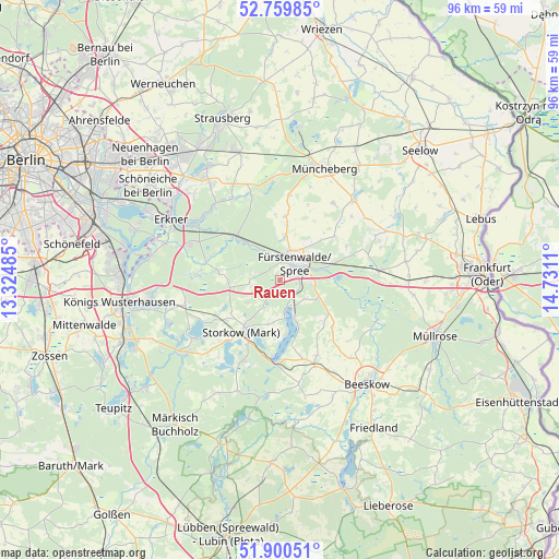
Rauen GPS coordinates[2]
52° 19' 56.172" North, 14° 1' 40.692" East
| Map corner | latitude | longitude |
|---|---|---|
| Upper-left | 52.75985°, | 13.32485° |
| Center: | 52.33227°, | 14.02797° |
| Lower-right: | 51.90051°, | 14.7311° |
| Map W x H: | 95.5×95.5 km | = 59.3×59.3mi |
| max Lat: | 55.01917° ⇑24.5% North |
| Rauen: | 52.33227° |
| min Lat: | ⇓75.5% South 47.40724° |
| min Long | Rauen | max Long |
| 5.92978° | 14.02797° | 14.98853° |
| W 98.1%⇐ | ⇒1.9% E |
Elevation
Elevation of Rauen is 70 m = 230 ft, and this is 179.1 m = 588 ft below average elevation for this country.
| Max E: |
1256 m = 4121 ft | 73.4% |
| Avg. | 249.1 m = 817 ft | |
| Rauen | 70 m = 230 ft | |
Min E: |
-5 m = -16 ft | 26.6% |
See also: Germany elevation on elevation.city.
Geographical zone
Rauen is located in North temperate zone (between Tropic of Cancer and the Arctic Circle). Distance of this North polar circle is 1582.4 km =983.3 mi to North.| Distance of | km | miles | from Rauen |
|---|---|---|---|
| North Pole | 4188.3 | 2602.5 | to North |
| Arctic Circle | 1582.4 | 983.3 | to North |
| Tropic Cancer | 3212.9 | 1996.4 | to South |
| Equator | 5818.8 | 3615.6 | to South |


Nearby cities:
15 places around Rauen: (largest is in red/bold)
• Bad Saarow
6 km =3.7 mi,  154°
154°
• Berkenbrück
8.5 km =5.3 mi,  76°
76°
• Briesen
17 km =10.6 mi,  85°
85°
• Diensdorf-Radlow
9.3 km =5.8 mi,  170°
170°
• Erkner
21 km =13 mi,  297°
297°
• Fürstenwalde
3.9 km =2.4 mi,  36°
36°
• Grünheide
17.8 km =11.1 mi, 304°
• Langewahl
4.9 km =3 mi, 88°
• Müncheberg
20.8 km =12.9 mi,  20°
20°
• Reichenwalde
7.5 km =4.7 mi,  194°
194°
• Rietz Neuendorf
15.3 km =9.5 mi,  139°
139°
• Spreenhagen
10.4 km =6.5 mi,  276°
276°
• Steinhöfel
12.1 km =7.5 mi,  51°
51°
• Storkow
10.6 km =6.6 mi,  217°
217°
• Wendisch Rietz
13 km =8.1 mi, 185°
Sources, notices
• [Note1] Compared only with cities in Germany existing in our database
• [Src1] Map data: © OpenStreetMap contributors (CC-BY-SA)
• [Src2] Other city data from geonames.org with taken over terms of usage.
• [Src3] Geographical zone / Annual Mean Temperature by Robert A. Rohde @ Wikipedia
