Schalkau geodata
Schalkau (Thuringia) is a populated place; located in Germany in Europe/Berlin (GMT+2) time zone. With population of 3,367 people, there are 3707 cities with bigger population in this country. Compared to other cities in Germany, 54.8% of cities are located further ↑North; 67.1% of cities are located further ←West and 75.5% of cities have lower elevation than Schalkau. Note1


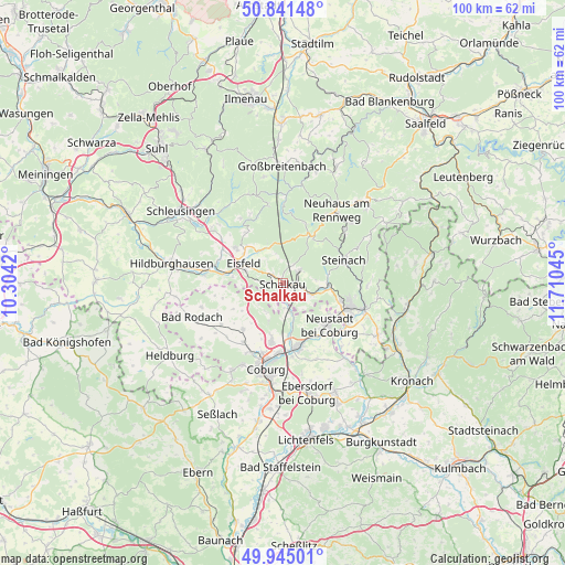
Schalkau GPS coordinates[2]
50° 23' 43.296" North, 11° 0' 26.352" East
| Map corner | latitude | longitude |
|---|---|---|
| Upper-left | 50.84148°, | 10.3042° |
| Center: | 50.39536°, | 11.00732° |
| Lower-right: | 49.94501°, | 11.71045° |
| Map W x H: | 99.7×99.7 km | = 62×62mi |
| max Lat: | 55.01917° ⇑54.8% North |
| Schalkau: | 50.39536° |
| min Lat: | ⇓45.2% South 47.40724° |
| min Long | Schalkau | max Long |
| 5.92978° | 11.00732° | 14.98853° |
| W 67.1%⇐ | ⇒32.9% E |
Elevation
Elevation of Schalkau is 401 m = 1316 ft, and this is 151.9 m = 498 ft above average elevation for this country.
| Max E: |
1256 m = 4121 ft | 24.5% |
| Schalkau | 401 m 1316 ft | |
| Avg. | 249.1 m = 817 ft | |
Min E: |
-5 m = -16 ft | 75.5% |
See also: Germany elevation on elevation.city.
Geographical zone
Schalkau is located in North temperate zone (between Tropic of Cancer and the Arctic Circle). Distance of this North polar circle is 1797.7 km =1117 mi to North.| Distance of | km | miles | from Schalkau |
|---|---|---|---|
| North Pole | 4403.6 | 2736.3 | to North |
| Arctic Circle | 1797.7 | 1117 | to North |
| Tropic Cancer | 2997.5 | 1862.6 | to South |
| Equator | 5603.4 | 3481.8 | to South |


Nearby cities:
15 places around Schalkau: (largest is in red/bold)
• Bachfeld
2.9 km =1.8 mi,  324°
324°
• Bockstadt
8.8 km =5.5 mi,  273°
273°
• Ebersdorf
12.7 km =7.9 mi,  125°
125°
• Eisfeld
7.9 km =4.9 mi,  295°
295°
• Goldisthal
13.5 km =8.4 mi,  357°
357°
• Lautertal
7.5 km =4.7 mi,  202°
202°
• Meeder
10.9 km =6.8 mi,  220°
220°
• Mengersgereuth-Hämmern
7.7 km =4.8 mi,  88°
88°
• Neustadt bei Coburg
10.9 km =6.8 mi, 132°
• Rödental
11.4 km =7.1 mi,  167°
167°
• Sachsenbrunn
7.1 km =4.4 mi, 324°
• Scheibe-Alsbach
11 km =6.8 mi,  20°
20°
• Sonneberg
12.5 km =7.8 mi,  108°
108°
• Steinach
11.5 km =7.1 mi,  69°
69°
• Steinheid
9.4 km =5.8 mi,  34°
34°
Sources, notices
• [Note1] Compared only with cities in Germany existing in our database
• [Src1] Map data: © OpenStreetMap contributors (CC-BY-SA)
• [Src2] Other city data from geonames.org with taken over terms of usage.
• [Src3] Geographical zone / Annual Mean Temperature by Robert A. Rohde @ Wikipedia
