Pfarrweisach geodata
Pfarrweisach (Bavaria) is a seat of a fourth-order administrative division; located in Germany in Europe/Berlin (GMT+2) time zone. With population of 1,608 people, there are 5669 cities with bigger population in this country. Compared to other cities in Germany, 60.2% of cities are located further ↑North; 63% of cities are located further ←West and 61.5% of cities have lower elevation than Pfarrweisach. Note1
Administrative division(s):
- Level 1: Bavaria
- Level 2: Regierungsbezirk Unterfranken
- Level 3: Landkreis Haßberge
- Level 4: Pfarrweisach


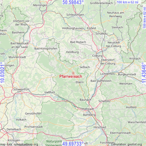
Pfarrweisach GPS coordinates[2]
50° 9' 0" North, 10° 43' 59.988" East
| Map corner | latitude | longitude |
|---|---|---|
| Upper-left | 50.59843°, | 10.03021° |
| Center: | 50.15°, | 10.73333° |
| Lower-right: | 49.69733°, | 11.43646° |
| Map W x H: | 100.2×100.2 km | = 62.3×62.3mi |
| max Lat: | 55.01917° ⇑60.2% North |
| Pfarrweisach: | 50.15° |
| min Lat: | ⇓39.8% South 47.40724° |
| min Long | Pfarrweisach | max Long |
| 5.92978° | 10.73333° | 14.98853° |
| W 63%⇐ | ⇒37% E |
Elevation
Elevation of Pfarrweisach is 299 m = 981 ft, and this is 49.9 m = 164 ft above average elevation for this country.
| Max E: |
1256 m = 4121 ft | 38.5% |
| Pfarrweisach | 299 m 981 ft | |
| Avg. | 249.1 m = 817 ft | |
Min E: |
-5 m = -16 ft | 61.5% |
See also: Germany elevation on elevation.city.
Geographical zone
Pfarrweisach is located in North temperate zone (between Tropic of Cancer and the Arctic Circle). Distance of this North polar circle is 1825 km =1134 mi to North.| Distance of | km | miles | from Pfarrweisach |
|---|---|---|---|
| North Pole | 4430.9 | 2753.2 | to North |
| Arctic Circle | 1825 | 1134 | to North |
| Tropic Cancer | 2970.2 | 1845.6 | to South |
| Equator | 5576.2 | 3464.9 | to South |


Nearby cities:
15 places around Pfarrweisach: (largest is in red/bold)
• Breitbrunn
15 km =9.3 mi,  189°
189°
• Burgpreppach
6 km =3.7 mi,  260°
260°
• Ermershausen
10 km =6.2 mi,  310°
310°
• Gerach
13.8 km =8.6 mi,  159°
159°
• Großheirath
15.7 km =9.8 mi,  79°
79°
• Hellingen
11.7 km =7.3 mi,  342°
342°
• Hofheim in Unterfranken
15 km =9.3 mi, 264°
• Kirchlauter
11.8 km =7.3 mi, 185°
• Maroldsweisach
7.3 km =4.5 mi, 314°
• Reckendorf
16.5 km =10.3 mi,  154°
154°
• Rentweinsdorf
10.7 km =6.6 mi, 153°
• Seßlach
8.9 km =5.5 mi,  60°
60°
• Ummerstadt
13.3 km =8.3 mi,  24°
24°
• Untermerzbach
9.1 km =5.7 mi,  105°
105°
• Weitramsdorf
15.7 km =9.8 mi,  41°
41°
Sources, notices
• [Note1] Compared only with cities in Germany existing in our database
• [Src1] Map data: © OpenStreetMap contributors (CC-BY-SA)
• [Src2] Other city data from geonames.org with taken over terms of usage.
• [Src3] Geographical zone / Annual Mean Temperature by Robert A. Rohde @ Wikipedia
