Hannover geodata
Hannover (Lower Saxony) is a seat of a first-order administrative division; located in Germany in Europe/Berlin (GMT+2) time zone. With population of 515,140 people, there are 10 cities with bigger population in this country. Compared to other cities in Germany, 75.9% of cities are located further ↓South; 53.9% of cities are located further →East and 76.7% of cities have higher elevation than Hannover. Note1
Administrative division(s):
- Level 1: Lower Saxony
- Level 3: Region Hannover
- Level 4: Hannover, Landeshauptstadt


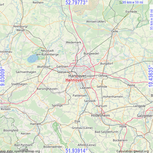
Hannover GPS coordinates[2]
52° 22' 13.872" North, 9° 43' 59.592" East
| Map corner | latitude | longitude |
|---|---|---|
| Upper-left | 52.79773°, | 9.03009° |
| Center: | 52.37052°, | 9.73322° |
| Lower-right: | 51.93914°, | 10.43635° |
| Map W x H: | 95.5×95.5 km | = 59.3×59.3mi |
| max Lat: | 55.01917° ⇑24.1% North |
| Hannover: | 52.37052° |
| min Lat: | ⇓75.9% South 47.40724° |
| min Long | Hannover | max Long |
| 5.92978° | 9.73322° | 14.98853° |
| W 46.1%⇐ | ⇒53.9% E |
Elevation
Elevation of Hannover is 57 m = 187 ft, and this is 192.1 m = 630 ft below average elevation for this country.
| Max E: |
1256 m = 4121 ft | 76.7% |
| Avg. | 249.1 m = 817 ft | |
| Hannover | 57 m = 187 ft | |
Min E: |
-5 m = -16 ft | 23.3% |
See also: Hannover elevation on elevation.city.
Geographical zone
Hannover is located in North temperate zone (between Tropic of Cancer and the Arctic Circle). Distance of this North polar circle is 1578.1 km =980.6 mi to North.| Distance of | km | miles | from Hannover |
|---|---|---|---|
| North Pole | 4184 | 2599.8 | to North |
| Arctic Circle | 1578.1 | 980.6 | to North |
| Tropic Cancer | 3217.1 | 1999 | to South |
| Equator | 5823.1 | 3618.3 | to South |


Nearby cities:
15 places around Hannover: (largest is in red/bold)
• Auf der Horst
10.4 km =6.5 mi,  301°
301°
• Garbsen
10.8 km =6.7 mi, 296°
• Garbsen-Mitte
10.8 km =6.7 mi,  305°
305°
• Gehrden
11 km =6.8 mi,  234°
234°
• Großgoltern
16.3 km =10.1 mi,  255°
255°
• Hemmingen
6.3 km =3.9 mi,  185°
185°
• Isernhagen Farster Bauerschaft
13.4 km =8.3 mi,  33°
33°
• Laatzen
7.6 km =4.7 mi,  144°
144°
• Langenhagen
8.6 km =5.3 mi,  1°
1°
• Lehrte
16.7 km =10.4 mi,  89°
89°
• Pattensen
12 km =7.5 mi,  169°
169°
• Ronnenberg
7.8 km =4.8 mi,  222°
222°
• Seelze
9.7 km =6 mi,  287°
287°
• Sehnde
17.2 km =10.7 mi,  111°
111°
• Wennigsen
15.3 km =9.5 mi, 225°
Sources, notices
• [Note1] Compared only with cities in Germany existing in our database
• [Src1] Map data: © OpenStreetMap contributors (CC-BY-SA)
• [Src2] Other city data from geonames.org with taken over terms of usage.
• [Src3] Geographical zone / Annual Mean Temperature by Robert A. Rohde @ Wikipedia
