Langenhagen geodata
Langenhagen (Lower Saxony) is a seat of a fourth-order administrative division; located in Germany in Europe/Berlin (GMT+2) time zone. With population of 50,439 people, there are 222 cities with bigger population in this country. Compared to other cities in Germany, 76.9% of cities are located further ↓South; 53.7% of cities are located further →East and 77.5% of cities have higher elevation than Langenhagen. Note1


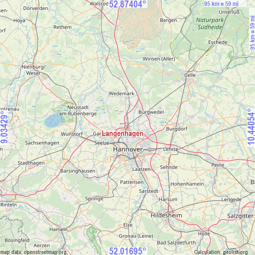
Langenhagen GPS coordinates[2]
52° 26' 51.288" North, 9° 44' 14.676" East
| Map corner | latitude | longitude |
|---|---|---|
| Upper-left | 52.87404°, | 9.03429° |
| Center: | 52.44758°, | 9.73741° |
| Lower-right: | 52.01695°, | 10.44054° |
| Map W x H: | 95.3×95.3 km | = 59.2×59.2mi |
| max Lat: | 55.01917° ⇑23.1% North |
| Langenhagen: | 52.44758° |
| min Lat: | ⇓76.9% South 47.40724° |
| min Long | Langenhagen | max Long |
| 5.92978° | 9.73741° | 14.98853° |
| W 46.3%⇐ | ⇒53.7% E |
Elevation
Elevation of Langenhagen is 54 m = 177 ft, and this is 195.1 m = 640 ft below average elevation for this country.
| Max E: |
1256 m = 4121 ft | 77.5% |
| Avg. | 249.1 m = 817 ft | |
| Langenhagen | 54 m = 177 ft | |
Min E: |
-5 m = -16 ft | 22.5% |
See also: Langenhagen elevation on elevation.city.
Geographical zone
Langenhagen is located in North temperate zone (between Tropic of Cancer and the Arctic Circle). Distance of this North polar circle is 1569.5 km =975.2 mi to North.| Distance of | km | miles | from Langenhagen |
|---|---|---|---|
| North Pole | 4175.4 | 2594.5 | to North |
| Arctic Circle | 1569.5 | 975.2 | to North |
| Tropic Cancer | 3225.7 | 2004.4 | to South |
| Equator | 5831.6 | 3623.6 | to South |


Nearby cities:
15 places around Langenhagen: (largest is in red/bold)
• Auf der Horst
9.7 km =6 mi,  251°
251°
• Burgdorf
18.2 km =11.3 mi,  90°
90°
• Elze
14.9 km =9.3 mi,  359°
359°
• Garbsen
10.7 km =6.6 mi, 249°
• Garbsen-Mitte
9.4 km =5.8 mi,  255°
255°
• Gehrden
17.6 km =10.9 mi,  211°
211°
• Hannover
8.6 km =5.3 mi,  181°
181°
• Hemmingen
14.9 km =9.3 mi, 183°
• Isernhagen Farster Bauerschaft
7.5 km =4.7 mi,  69°
69°
• Laatzen
15.3 km =9.5 mi,  164°
164°
• Lehrte
18.4 km =11.4 mi,  117°
117°
• Lindwedel
18.1 km =11.2 mi,  349°
349°
• Negenborn
13.8 km =8.6 mi,  328°
328°
• Ronnenberg
15.3 km =9.5 mi,  201°
201°
• Seelze
11.1 km =6.9 mi,  239°
239°
Sources, notices
• [Note1] Compared only with cities in Germany existing in our database
• [Src1] Map data: © OpenStreetMap contributors (CC-BY-SA)
• [Src2] Other city data from geonames.org with taken over terms of usage.
• [Src3] Geographical zone / Annual Mean Temperature by Robert A. Rohde @ Wikipedia
