Mackenbach geodata
Mackenbach (Rheinland-Pfalz) is a seat of a fourth-order administrative division; located in Germany in Europe/Berlin (GMT+2) time zone. With population of 2,119 people, there are 4905 cities with bigger population in this country. Compared to other cities in Germany, 76.3% of cities are located further ↑North; 85.4% of cities are located further →East and 57.6% of cities have lower elevation than Mackenbach. Note1
Administrative division(s):
- Level 1: Rheinland-Pfalz
- Level 3: Landkreis Kaiserslautern
- Level 4: Mackenbach


Mackenbach GPS coordinates[2]
49° 28' 0.012" North, 7° 34' 59.988" East
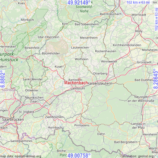
| Map corner | latitude | longitude |
|---|---|---|
| Upper-left | 49.92149°, | 6.8802° |
| Center: | 49.46667°, | 7.58333° |
| Lower-right: | 49.00758°, | 8.28645° |
| Map W x H: | 101.6×101.6 km | = 63.1×63.1mi |
| max Lat: | 55.01917° ⇑76.3% North |
| Mackenbach: | 49.46667° |
| min Lat: | ⇓23.7% South 47.40724° |
| min Long | Mackenbach | max Long |
| 5.92978° | 7.58333° | 14.98853° |
| W 14.6%⇐ | ⇒85.4% E |
Elevation
Elevation of Mackenbach is 276 m = 906 ft, and this is 26.9 m = 88 ft above average elevation for this country.
| Max E: |
1256 m = 4121 ft | 42.4% |
| Mackenbach | 276 m 906 ft | |
| Avg. | 249.1 m = 817 ft | |
Min E: |
-5 m = -16 ft | 57.6% |
See also: Germany elevation on elevation.city.
Geographical zone
Mackenbach is located in North temperate zone (between Tropic of Cancer and the Arctic Circle). Distance of this North polar circle is 1901 km =1181.2 mi to North.| Distance of | km | miles | from Mackenbach |
|---|---|---|---|
| North Pole | 4506.9 | 2800.5 | to North |
| Arctic Circle | 1901 | 1181.2 | to North |
| Tropic Cancer | 2894.3 | 1798.4 | to South |
| Equator | 5500.2 | 3417.7 | to South |


Nearby cities:
15 places around Mackenbach: (largest is in red/bold)
• Erzenhausen
4.4 km =2.7 mi,  33°
33°
• Eulenbis
5.2 km =3.2 mi,  44°
44°
• Jettenbach
7.8 km =4.8 mi,  346°
346°
• Kindsbach
6.1 km =3.8 mi,  156°
156°
• Kollweiler
5.6 km =3.5 mi,  0°
0°
• Kottweiler-Schwanden
4.1 km =2.5 mi,  297°
297°
• Landstuhl
6 km =3.7 mi,  189°
189°
• Neunkirchen am Potzberg
8.1 km =5 mi, 297°
• Oberstaufenbach
7.6 km =4.7 mi,  315°
315°
• Ramstein-Miesenbach
3.2 km =2 mi,  219°
219°
• Reichenbach-Steegen
4.4 km =2.7 mi,  326°
326°
• Rodenbach
5.4 km =3.4 mi,  82°
82°
• Schwedelbach
3.3 km =2.1 mi,  13°
13°
• Steinwenden
4.2 km =2.6 mi,  255°
255°
• Weilerbach
4.1 km =2.5 mi,  62°
62°
Sources, notices
• [Note1] Compared only with cities in Germany existing in our database
• [Src1] Map data: © OpenStreetMap contributors (CC-BY-SA)
• [Src2] Other city data from geonames.org with taken over terms of usage.
• [Src3] Geographical zone / Annual Mean Temperature by Robert A. Rohde @ Wikipedia
