Steinwenden geodata
Steinwenden (Rheinland-Pfalz) is a seat of a fourth-order administrative division; located in Germany in Europe/Berlin (GMT+2) time zone. With population of 2,535 people, there are 4397 cities with bigger population in this country. Compared to other cities in Germany, 76.4% of cities are located further ↑North; 86.5% of cities are located further →East and 52.5% of cities have lower elevation than Steinwenden. Note1
Administrative division(s):
- Level 1: Rheinland-Pfalz
- Level 3: Landkreis Kaiserslautern
- Level 4: Steinwenden


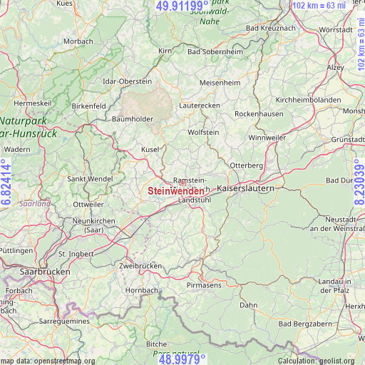
Steinwenden GPS coordinates[2]
49° 27' 25.488" North, 7° 31' 38.136" East
| Map corner | latitude | longitude |
|---|---|---|
| Upper-left | 49.91199°, | 6.82414° |
| Center: | 49.45708°, | 7.52726° |
| Lower-right: | 48.9979°, | 8.23039° |
| Map W x H: | 101.6×101.6 km | = 63.1×63.1mi |
| max Lat: | 55.01917° ⇑76.4% North |
| Steinwenden: | 49.45708° |
| min Lat: | ⇓23.6% South 47.40724° |
| min Long | Steinwenden | max Long |
| 5.92978° | 7.52726° | 14.98853° |
| W 13.5%⇐ | ⇒86.5% E |
Elevation
Elevation of Steinwenden is 243 m = 797 ft, and this is 6.1 m = 20 ft below average elevation for this country.
| Max E: |
1256 m = 4121 ft | 47.5% |
| Avg. | 249.1 m = 817 ft | |
| Steinwenden | 243 m = 797 ft | |
Min E: |
-5 m = -16 ft | 52.5% |
See also: Germany elevation on elevation.city.
Geographical zone
Steinwenden is located in North temperate zone (between Tropic of Cancer and the Arctic Circle). Distance of this North polar circle is 1902.1 km =1181.9 mi to North.| Distance of | km | miles | from Steinwenden |
|---|---|---|---|
| North Pole | 4508 | 2801.1 | to North |
| Arctic Circle | 1902.1 | 1181.9 | to North |
| Tropic Cancer | 2893.2 | 1797.8 | to South |
| Equator | 5499.1 | 3417 | to South |


Nearby cities:
15 places around Steinwenden: (largest is in red/bold)
• Glan-Münchweiler
6.4 km =4 mi,  285°
285°
• Hauptstuhl
7.1 km =4.4 mi,  206°
206°
• Hütschenhausen
5.5 km =3.4 mi,  215°
215°
• Kottweiler-Schwanden
3 km =1.9 mi,  8°
8°
• Landstuhl
5.8 km =3.6 mi,  147°
147°
• Mackenbach
4.2 km =2.6 mi,  75°
75°
• Matzenbach
6.5 km =4 mi,  317°
317°
• Nanzdietschweiler
5.6 km =3.5 mi,  261°
261°
• Neunkirchen am Potzberg
5.7 km =3.5 mi,  326°
326°
• Niedermohr
4.2 km =2.6 mi,  272°
272°
• Oberstaufenbach
6.7 km =4.2 mi,  349°
349°
• Ramstein-Miesenbach
2.5 km =1.6 mi,  124°
124°
• Rehweiler
6.9 km =4.3 mi,  297°
297°
• Reichenbach-Steegen
5 km =3.1 mi,  18°
18°
• Schwedelbach
6.4 km =4 mi,  48°
48°
Sources, notices
• [Note1] Compared only with cities in Germany existing in our database
• [Src1] Map data: © OpenStreetMap contributors (CC-BY-SA)
• [Src2] Other city data from geonames.org with taken over terms of usage.
• [Src3] Geographical zone / Annual Mean Temperature by Robert A. Rohde @ Wikipedia
