Feucht geodata
Feucht (Bavaria) is a populated place; located in Germany in Europe/Berlin (GMT+2) time zone. With population of 13,482 people, there are 1190 cities with bigger population in this country. Compared to other cities in Germany, 77.5% of cities are located further ↑North; 70.1% of cities are located further ←West and 70.1% of cities have lower elevation than Feucht. Note1
Administrative division(s):
- Level 1: Bavaria
- Level 2: Regierungsbezirk Mittelfranken
- Level 3: Nürnberger Land
- Level 4: Feucht, Markt


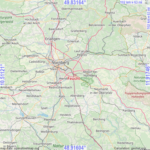
Feucht GPS coordinates[2]
49° 22' 33.492" North, 11° 12' 51.588" East
| Map corner | latitude | longitude |
|---|---|---|
| Upper-left | 49.83164°, | 10.51121° |
| Center: | 49.37597°, | 11.21433° |
| Lower-right: | 48.91604°, | 11.91746° |
| Map W x H: | 101.8×101.8 km | = 63.3×63.3mi |
| max Lat: | 55.01917° ⇑77.5% North |
| Feucht: | 49.37597° |
| min Lat: | ⇓22.5% South 47.40724° |
| min Long | Feucht | max Long |
| 5.92978° | 11.21433° | 14.98853° |
| W 70.1%⇐ | ⇒29.9% E |
Elevation
Elevation of Feucht is 359 m = 1178 ft, and this is 109.9 m = 361 ft above average elevation for this country.
| Max E: |
1256 m = 4121 ft | 29.9% |
| Feucht | 359 m 1178 ft | |
| Avg. | 249.1 m = 817 ft | |
Min E: |
-5 m = -16 ft | 70.1% |
See also: Germany elevation on elevation.city.
Geographical zone
Feucht is located in North temperate zone (between Tropic of Cancer and the Arctic Circle). Distance of this North polar circle is 1911.1 km =1187.5 mi to North.| Distance of | km | miles | from Feucht |
|---|---|---|---|
| North Pole | 4517 | 2806.7 | to North |
| Arctic Circle | 1911.1 | 1187.5 | to North |
| Tropic Cancer | 2884.2 | 1792.2 | to South |
| Equator | 5490.1 | 3411.4 | to South |


Nearby cities:
15 places around Feucht: (largest is in red/bold)
• Allersberg
14 km =8.7 mi,  173°
173°
• Altdorf
10.4 km =6.5 mi,  84°
84°
• Burgthann
7.5 km =4.7 mi,  110°
110°
• Leinburg
10.9 km =6.8 mi,  39°
39°
• Nürnberg
13.2 km =8.2 mi,  311°
311°
• Postbauer-Heng
13 km =8.1 mi,  127°
127°
• Pyrbaum
10.3 km =6.4 mi,  149°
149°
• Rednitzhembach
12.8 km =8 mi,  229°
229°
• Röthenbach an der Pegnitz
12.1 km =7.5 mi,  9°
9°
• Rückersdorf
13.7 km =8.5 mi, 10°
• Schwabach
14.7 km =9.1 mi,  249°
249°
• Schwaig
10.5 km =6.5 mi,  354°
354°
• Schwarzenbruck
2.9 km =1.8 mi, 133°
• Wendelstein
5.3 km =3.3 mi,  240°
240°
• Winkelhaid
6.3 km =3.9 mi, 76°
Sources, notices
• [Note1] Compared only with cities in Germany existing in our database
• [Src1] Map data: © OpenStreetMap contributors (CC-BY-SA)
• [Src2] Other city data from geonames.org with taken over terms of usage.
• [Src3] Geographical zone / Annual Mean Temperature by Robert A. Rohde @ Wikipedia
