Schwäbisch Hall geodata
Schwäbisch Hall (Baden-Württemberg) is a seat of a third-order administrative division; located in Germany in Europe/Berlin (GMT+2) time zone. With population of 36,543 people, there are 364 cities with bigger population in this country. Compared to other cities in Germany, 81.6% of cities are located further ↑North; 53.7% of cities are located further →East and 65.1% of cities have lower elevation than Schwäbisch Hall. Note1
Administrative division(s):
- Level 1: Baden-Württemberg
- Level 2: Regierungsbezirk Stuttgart
- Level 3: Landkreis Schwäbisch Hall
- Level 4: Schwäbisch Hall


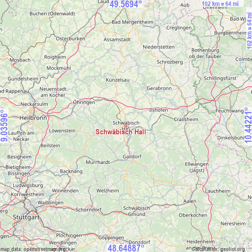
Schwäbisch Hall GPS coordinates[2]
49° 6' 40.572" North, 9° 44' 20.688" East
| Map corner | latitude | longitude |
|---|---|---|
| Upper-left | 49.5694°, | 9.03596° |
| Center: | 49.11127°, | 9.73908° |
| Lower-right: | 48.64887°, | 10.44221° |
| Map W x H: | 102.4×102.4 km | = 63.6×63.6mi |
| max Lat: | 55.01917° ⇑81.6% North |
| Schwäbisch Hall: | 49.11127° |
| min Lat: | ⇓18.4% South 47.40724° |
| min Long | Schwäbisch Hal | max Long |
| 5.92978° | 9.73908° | 14.98853° |
| W 46.3%⇐ | ⇒53.7% E |
Elevation
Elevation of Schwäbisch Hall is 322 m = 1056 ft, and this is 72.9 m = 239 ft above average elevation for this country.
| Max E: |
1256 m = 4121 ft | 34.9% |
| Schwäbisch Hall | 322 m 1056 ft | |
| Avg. | 249.1 m = 817 ft | |
Min E: |
-5 m = -16 ft | 65.1% |
See also: Germany elevation on elevation.city.
Geographical zone
Schwäbisch Hall is located in North temperate zone (between Tropic of Cancer and the Arctic Circle). Distance of this North polar circle is 1940.5 km =1205.8 mi to North.| Distance of | km | miles | from Schwäbisch Hall |
|---|---|---|---|
| North Pole | 4546.4 | 2825 | to North |
| Arctic Circle | 1940.5 | 1205.8 | to North |
| Tropic Cancer | 2854.7 | 1773.8 | to South |
| Equator | 5460.7 | 3393.1 | to South |


Nearby cities:
15 places around Schwäbisch Hall: (largest is in red/bold)
• Braunsbach
10.5 km =6.5 mi,  20°
20°
• Bühlertann
14.6 km =9.1 mi,  122°
122°
• Fichtenberg
14.1 km =8.8 mi,  188°
188°
• Gaildorf
12.5 km =7.8 mi,  169°
169°
• Ilshofen
14.6 km =9.1 mi,  63°
63°
• Kupferzell
13.4 km =8.3 mi,  344°
344°
• Mainhardt
13.9 km =8.6 mi,  253°
253°
• Michelbach an der Bilz
4.9 km =3 mi,  159°
159°
• Michelfeld
4.7 km =2.9 mi, 250°
• Oberrot
12 km =7.5 mi,  205°
205°
• Obersontheim
13.1 km =8.1 mi, 117°
• Untermünkheim
4.6 km =2.9 mi,  355°
355°
• Vellberg
10.6 km =6.6 mi,  106°
106°
• Waldenburg
10.9 km =6.8 mi,  318°
318°
• Wolpertshausen
9.9 km =6.2 mi,  50°
50°
Sources, notices
• [Note1] Compared only with cities in Germany existing in our database
• [Src1] Map data: © OpenStreetMap contributors (CC-BY-SA)
• [Src2] Other city data from geonames.org with taken over terms of usage.
• [Src3] Geographical zone / Annual Mean Temperature by Robert A. Rohde @ Wikipedia
