Mainhardt geodata
Mainhardt (Baden-Württemberg) is a seat of a fourth-order administrative division; located in Germany in Europe/Berlin (GMT+2) time zone. With population of 5,680 people, there are 2573 cities with bigger population in this country. Compared to other cities in Germany, 82% of cities are located further ↑North; 56.9% of cities are located further →East and 87.8% of cities have lower elevation than Mainhardt. Note1
Administrative division(s):
- Level 1: Baden-Württemberg
- Level 2: Regierungsbezirk Stuttgart
- Level 3: Landkreis Schwäbisch Hall
- Level 4: Mainhardt


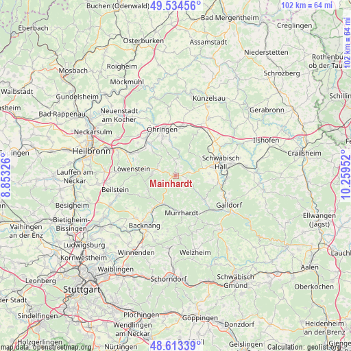
Mainhardt GPS coordinates[2]
49° 4' 33.996" North, 9° 33' 23.004" East
| Map corner | latitude | longitude |
|---|---|---|
| Upper-left | 49.53456°, | 8.85326° |
| Center: | 49.07611°, | 9.55639° |
| Lower-right: | 48.61339°, | 10.25952° |
| Map W x H: | 102.4×102.4 km | = 63.6×63.6mi |
| max Lat: | 55.01917° ⇑82% North |
| Mainhardt: | 49.07611° |
| min Lat: | ⇓18% South 47.40724° |
| min Long | Mainhardt | max Long |
| 5.92978° | 9.55639° | 14.98853° |
| W 43.1%⇐ | ⇒56.9% E |
Elevation
Elevation of Mainhardt is 492 m = 1614 ft, and this is 242.9 m = 797 ft above average elevation for this country.
| Max E: |
1256 m = 4121 ft | 12.2% |
| Mainhardt | 492 m 1614 ft | |
| Avg. | 249.1 m = 817 ft | |
Min E: |
-5 m = -16 ft | 87.8% |
See also: Germany elevation on elevation.city.
Geographical zone
Mainhardt is located in North temperate zone (between Tropic of Cancer and the Arctic Circle). Distance of this North polar circle is 1944.4 km =1208.2 mi to North.| Distance of | km | miles | from Mainhardt |
|---|---|---|---|
| North Pole | 4550.3 | 2827.4 | to North |
| Arctic Circle | 1944.4 | 1208.2 | to North |
| Tropic Cancer | 2850.8 | 1771.4 | to South |
| Equator | 5456.8 | 3390.7 | to South |


Nearby cities:
15 places around Mainhardt: (largest is in red/bold)
• Bretzfeld
14.3 km =8.9 mi,  323°
323°
• Großerlach
4 km =2.5 mi,  231°
231°
• Löwenstein
13 km =8.1 mi,  279°
279°
• Michelfeld
9.2 km =5.7 mi,  75°
75°
• Murrhardt
10.5 km =6.5 mi,  174°
174°
• Neuenstein
14.4 km =8.9 mi,  6°
6°
• Oberrot
10.6 km =6.6 mi,  130°
130°
• Oppenweiler
12.6 km =7.8 mi,  214°
214°
• Pfedelbach
11.9 km =7.4 mi,  341°
341°
• Schwäbisch Hall
13.9 km =8.6 mi,  73°
73°
• Spiegelberg
9.1 km =5.7 mi,  244°
244°
• Sulzbach an der Murr
9.1 km =5.7 mi, 206°
• Waldenburg
13.5 km =8.4 mi,  26°
26°
• Wüstenrot
7 km =4.3 mi,  274°
274°
• Öhringen
14.1 km =8.8 mi,  345°
345°
Sources, notices
• [Note1] Compared only with cities in Germany existing in our database
• [Src1] Map data: © OpenStreetMap contributors (CC-BY-SA)
• [Src2] Other city data from geonames.org with taken over terms of usage.
• [Src3] Geographical zone / Annual Mean Temperature by Robert A. Rohde @ Wikipedia
