Oberrot geodata
Oberrot (Baden-Württemberg) is a seat of a fourth-order administrative division; located in Germany in Europe/Berlin (GMT+2) time zone. With population of 3,713 people, there are 3464 cities with bigger population in this country. Compared to other cities in Germany, 82.9% of cities are located further ↑North; 54.9% of cities are located further →East and 70% of cities have lower elevation than Oberrot. Note1
Administrative division(s):
- Level 1: Baden-Württemberg
- Level 2: Regierungsbezirk Stuttgart
- Level 3: Landkreis Schwäbisch Hall
- Level 4: Oberrot


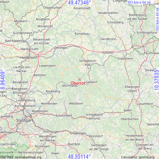
Oberrot GPS coordinates[2]
49° 0' 51.984" North, 9° 40' 1.992" East
| Map corner | latitude | longitude |
|---|---|---|
| Upper-left | 49.47346°, | 8.96409° |
| Center: | 49.01444°, | 9.66722° |
| Lower-right: | 48.55114°, | 10.37035° |
| Map W x H: | 102.6×102.6 km | = 63.8×63.8mi |
| max Lat: | 55.01917° ⇑82.9% North |
| Oberrot: | 49.01444° |
| min Lat: | ⇓17.1% South 47.40724° |
| min Long | Oberrot | max Long |
| 5.92978° | 9.66722° | 14.98853° |
| W 45.1%⇐ | ⇒54.9% E |
Elevation
Elevation of Oberrot is 358 m = 1175 ft, and this is 108.9 m = 357 ft above average elevation for this country.
| Max E: |
1256 m = 4121 ft | 30% |
| Oberrot | 358 m 1175 ft | |
| Avg. | 249.1 m = 817 ft | |
Min E: |
-5 m = -16 ft | 70% |
See also: Germany elevation on elevation.city.
Geographical zone
Oberrot is located in North temperate zone (between Tropic of Cancer and the Arctic Circle). Distance of this North polar circle is 1951.3 km =1212.5 mi to North.| Distance of | km | miles | from Oberrot |
|---|---|---|---|
| North Pole | 4557.2 | 2831.7 | to North |
| Arctic Circle | 1951.3 | 1212.5 | to North |
| Tropic Cancer | 2844 | 1767.2 | to South |
| Equator | 5449.9 | 3386.4 | to South |


Nearby cities:
15 places around Oberrot: (largest is in red/bold)
• Althütte
13.1 km =8.1 mi,  212°
212°
• Fichtenberg
4.5 km =2.8 mi,  134°
134°
• Gaildorf
7.6 km =4.7 mi,  101°
101°
• Großerlach
12 km =7.5 mi,  291°
291°
• Gschwend
10.6 km =6.6 mi,  148°
148°
• Kaisersbach
9.6 km =6 mi,  192°
192°
• Mainhardt
10.6 km =6.6 mi,  310°
310°
• Michelbach an der Bilz
9.3 km =5.8 mi,  48°
48°
• Michelfeld
9.3 km =5.8 mi,  5°
5°
• Murrhardt
7.9 km =4.9 mi,  242°
242°
• Oppenweiler
15.6 km =9.7 mi,  256°
256°
• Schwäbisch Hall
12 km =7.5 mi,  25°
25°
• Sulzbach an der Murr
12.2 km =7.6 mi, 264°
• Untermünkheim
16.1 km =10 mi,  17°
17°
• Welzheim
15.5 km =9.6 mi, 188°
Sources, notices
• [Note1] Compared only with cities in Germany existing in our database
• [Src1] Map data: © OpenStreetMap contributors (CC-BY-SA)
• [Src2] Other city data from geonames.org with taken over terms of usage.
• [Src3] Geographical zone / Annual Mean Temperature by Robert A. Rohde @ Wikipedia
