Creglingen geodata
Creglingen (Baden-Württemberg) is a populated place; located in Germany in Europe/Berlin (GMT+2) time zone. With population of 4,828 people, there are 2889 cities with bigger population in this country. Compared to other cities in Germany, 76.2% of cities are located further ↑North; 50.6% of cities are located further ←West and 57% of cities have lower elevation than Creglingen. Note1
Administrative division(s):
- Level 1: Baden-Württemberg
- Level 2: Regierungsbezirk Stuttgart
- Level 3: Main-Tauber-Kreis
- Level 4: Creglingen


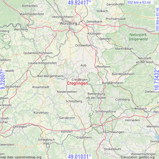
Creglingen GPS coordinates[2]
49° 28' 9.732" North, 10° 1' 52.284" East
| Map corner | latitude | longitude |
|---|---|---|
| Upper-left | 49.92417°, | 9.32807° |
| Center: | 49.46937°, | 10.03119° |
| Lower-right: | 49.01031°, | 10.73432° |
| Map W x H: | 101.6×101.6 km | = 63.1×63.1mi |
| max Lat: | 55.01917° ⇑76.2% North |
| Creglingen: | 49.46937° |
| min Lat: | ⇓23.8% South 47.40724° |
| min Long | Creglingen | max Long |
| 5.92978° | 10.03119° | 14.98853° |
| W 50.6%⇐ | ⇒49.4% E |
Elevation
Elevation of Creglingen is 272 m = 892 ft, and this is 22.9 m = 75 ft above average elevation for this country.
| Max E: |
1256 m = 4121 ft | 43% |
| Creglingen | 272 m 892 ft | |
| Avg. | 249.1 m = 817 ft | |
Min E: |
-5 m = -16 ft | 57% |
See also: Germany elevation on elevation.city.
Geographical zone
Creglingen is located in North temperate zone (between Tropic of Cancer and the Arctic Circle). Distance of this North polar circle is 1900.7 km =1181 mi to North.| Distance of | km | miles | from Creglingen |
|---|---|---|---|
| North Pole | 4506.6 | 2800.3 | to North |
| Arctic Circle | 1900.7 | 1181 | to North |
| Tropic Cancer | 2894.6 | 1798.6 | to South |
| Equator | 5500.5 | 3417.9 | to South |


Nearby cities:
15 places around Creglingen: (largest is in red/bold)
• Adelshofen
10.6 km =6.6 mi,  112°
112°
• Aub
9.6 km =6 mi,  14°
14°
• Bieberehren
5.6 km =3.5 mi,  343°
343°
• Gelchsheim
11.5 km =7.1 mi,  356°
356°
• Hemmersheim
11.4 km =7.1 mi,  24°
24°
• Niederstetten
11.2 km =7 mi,  226°
226°
• Ohrenbach
12.9 km =8 mi,  89°
89°
• Riedenheim
10.5 km =6.5 mi, 338°
• Röttingen
6.3 km =3.9 mi,  315°
315°
• Schrozberg
14.3 km =8.9 mi,  195°
195°
• Simmershofen
10.2 km =6.3 mi,  46°
46°
• Sonderhofen
13.9 km =8.6 mi,  351°
351°
• Steinsfeld
14.6 km =9.1 mi, 113°
• Tauberrettersheim
7.4 km =4.6 mi,  292°
292°
• Weikersheim
9.6 km =6 mi,  276°
276°
Sources, notices
• [Note1] Compared only with cities in Germany existing in our database
• [Src1] Map data: © OpenStreetMap contributors (CC-BY-SA)
• [Src2] Other city data from geonames.org with taken over terms of usage.
• [Src3] Geographical zone / Annual Mean Temperature by Robert A. Rohde @ Wikipedia
