Griesstätt geodata
Griesstätt (Bavaria) is a seat of a fourth-order administrative division; located in Germany in Europe/Berlin (GMT+2) time zone. With population of 2,485 people, there are 4457 cities with bigger population in this country. Compared to other cities in Germany, 95.6% of cities are located further ↑North; 84.3% of cities are located further ←West and 87.8% of cities have lower elevation than Griesstätt. Note1
Administrative division(s):
- Level 1: Bavaria
- Level 2: Upper Bavaria
- Level 3: Landkreis Rosenheim
- Level 4: Griesstätt


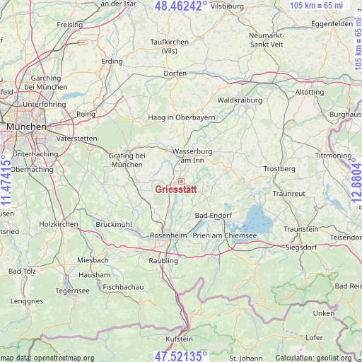
Griesstätt GPS coordinates[2]
47° 59' 38.508" North, 12° 10' 38.172" East
| Map corner | latitude | longitude |
|---|---|---|
| Upper-left | 48.46242°, | 11.47415° |
| Center: | 47.99403°, | 12.17727° |
| Lower-right: | 47.52135°, | 12.8804° |
| Map W x H: | 104.6×104.6 km | = 65×65mi |
| max Lat: | 55.01917° ⇑95.6% North |
| Griesstätt: | 47.99403° |
| min Lat: | ⇓4.4% South 47.40724° |
| min Long | Griesstätt | max Long |
| 5.92978° | 12.17727° | 14.98853° |
| W 84.3%⇐ | ⇒15.7% E |
Elevation
Elevation of Griesstätt is 492 m = 1614 ft, and this is 242.9 m = 797 ft above average elevation for this country.
| Max E: |
1256 m = 4121 ft | 12.2% |
| Griesstätt | 492 m 1614 ft | |
| Avg. | 249.1 m = 817 ft | |
Min E: |
-5 m = -16 ft | 87.8% |
See also: Germany elevation on elevation.city.
Geographical zone
Griesstätt is located in North temperate zone (between Tropic of Cancer and the Arctic Circle). Distance of this North polar circle is 2064.7 km =1282.9 mi to North.| Distance of | km | miles | from Griesstätt |
|---|---|---|---|
| North Pole | 4670.6 | 2902.2 | to North |
| Arctic Circle | 2064.7 | 1282.9 | to North |
| Tropic Cancer | 2730.5 | 1696.7 | to South |
| Equator | 5336.4 | 3315.9 | to South |


Nearby cities:
15 places around Griesstätt: (largest is in red/bold)
• Amerang
9.7 km =6 mi,  91°
91°
• Breitbrunn
5.7 km =3.5 mi,  342°
342°
• Edling
7 km =4.3 mi,  352°
352°
• Eiselfing
7.2 km =4.5 mi,  42°
42°
• Emmering
9 km =5.6 mi,  272°
272°
• Fraueneuharting
10.8 km =6.7 mi,  297°
297°
• Halfing
8.7 km =5.4 mi,  122°
122°
• Pfaffing
8.4 km =5.2 mi,  323°
323°
• Ramerberg
3.6 km =2.2 mi, 318°
• Rott
10.6 km =6.6 mi,  219°
219°
• Schechen
8.2 km =5.1 mi,  208°
208°
• Schonstett
5.5 km =3.4 mi,  102°
102°
• Söchtenau
8 km =5 mi,  150°
150°
• Vogtareuth
5.2 km =3.2 mi,  176°
176°
• Wasserburg am Inn
7.4 km =4.6 mi,  27°
27°
Sources, notices
• [Note1] Compared only with cities in Germany existing in our database
• [Src1] Map data: © OpenStreetMap contributors (CC-BY-SA)
• [Src2] Other city data from geonames.org with taken over terms of usage.
• [Src3] Geographical zone / Annual Mean Temperature by Robert A. Rohde @ Wikipedia
