Hassel geodata
Hassel (Saxony-Anhalt) is a seat of a fourth-order administrative division; located in Germany in Europe/Berlin (GMT+2) time zone. With population of 849 people, there are 7709 cities with bigger population in this country. Compared to other cities in Germany, 79.2% of cities are located further ↓South; 80.7% of cities are located further ←West and 85.8% of cities have higher elevation than Hassel. Note1


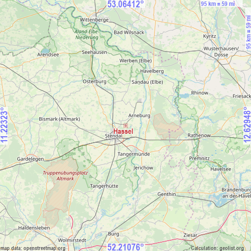
Hassel GPS coordinates[2]
52° 38' 22.272" North, 11° 55' 34.86" East
| Map corner | latitude | longitude |
|---|---|---|
| Upper-left | 53.06412°, | 11.22323° |
| Center: | 52.63952°, | 11.92635° |
| Lower-right: | 52.21076°, | 12.62948° |
| Map W x H: | 94.9×94.9 km | = 59×59mi |
| max Lat: | 55.01917° ⇑20.8% North |
| Hassel: | 52.63952° |
| min Lat: | ⇓79.2% South 47.40724° |
| min Long | Hassel | max Long |
| 5.92978° | 11.92635° | 14.98853° |
| W 80.7%⇐ | ⇒19.3% E |
Elevation
Elevation of Hassel is 33 m = 108 ft, and this is 216.1 m = 709 ft below average elevation for this country.
| Max E: |
1256 m = 4121 ft | 85.8% |
| Avg. | 249.1 m = 817 ft | |
| Hassel | 33 m = 108 ft | |
Min E: |
-5 m = -16 ft | 14.2% |
See also: Germany elevation on elevation.city.
Geographical zone
Hassel is located in North temperate zone (between Tropic of Cancer and the Arctic Circle). Distance of this North polar circle is 1548.2 km =962 mi to North.| Distance of | km | miles | from Hassel |
|---|---|---|---|
| North Pole | 4154.1 | 2581.2 | to North |
| Arctic Circle | 1548.2 | 962 | to North |
| Tropic Cancer | 3247 | 2017.6 | to South |
| Equator | 5853 | 3636.9 | to South |


Nearby cities:
15 places around Hassel: (largest is in red/bold)
• Arneburg
6.7 km =4.2 mi,  52°
52°
• Dahlen
11.1 km =6.9 mi,  217°
217°
• Fischbeck
12.7 km =7.9 mi,  151°
151°
• Goldbeck
9.7 km =6 mi,  332°
332°
• Heeren
11.1 km =6.9 mi,  194°
194°
• Hohenberg-Krusemark
9.6 km =6 mi,  8°
8°
• Insel
14.5 km =9 mi,  233°
233°
• Jarchau
2.7 km =1.7 mi,  310°
310°
• Klietz
10.1 km =6.3 mi,  71°
71°
• Möringen
13.3 km =8.3 mi,  246°
246°
• Rochau
14.4 km =8.9 mi,  301°
301°
• Schönhausen
10 km =6.2 mi,  130°
130°
• Stendal
5.8 km =3.6 mi, 231°
• Tangermünde
11.1 km =6.9 mi,  162°
162°
• Uenglingen
8.3 km =5.2 mi, 253°
Sources, notices
• [Note1] Compared only with cities in Germany existing in our database
• [Src1] Map data: © OpenStreetMap contributors (CC-BY-SA)
• [Src2] Other city data from geonames.org with taken over terms of usage.
• [Src3] Geographical zone / Annual Mean Temperature by Robert A. Rohde @ Wikipedia
